The use of technology has revolutionized the agricultural landscape around the world. One of the most transformative tools reshaping farming today is GIS technology in agriculture. With Geographic Information Systems (GIS), farmers can now perform advanced monitoring, analysis, and planning—benefiting both productivity and environmental sustainability. Whether it’s tracking crop growth, managing irrigation, or assessing soil quality, GIS in agriculture is enabling smarter, data-driven decisions.
As global food demands rise alongside population growth, the application of GIS in agriculture becomes even more essential. Let’s explore how GIS supports precision farming and drives informed decision-making for a greener, more efficient future.
Let’s explore the role of GIS in agriculture and how it can help in making informed decisions for a better and greener future.
How Can GIS Improve Your Farm’s Productivity?
Use GIS Navigator to optimize crop planning, monitor soil health, and maximize yields.
📞 Schedule a Call | 📩 Email Us | 💼 Get a Quote Now
1. What is GIS in Agriculture?
GIS in agriculture is used in modern agriculture for several reasons.
For example; this concept is beneficial for capturing, storing and visualizing geographic data that is related to farmer’s agricultural lands. In addition to that, farmers can also analyze the data in detail to make informed decisions.
GIS allows farmers, agriculturists and other stakeholders to map and monitor various factors. This can include the soil type, crop health, weather patterns and more. We must also mention that farmers, etc., can also study the patterns of water availability in different locations.
GIS helps farmers perform a number of actions ensuring that the data is not only highly detailed and accurate but also allows for sustainable decision-making.
Farmers can make the most of GIS by getting their hands on spatial data that is gathered through satellites and drones. By utilizing modern technology, farmers can view their fields in a precise manner.
One of the advantages of using GIS for agriculture is its ability to layer complex data, making it easier for farmers to monitor crops, soil, and water distribution all in one place.
Moreover, they can study the layers in detail in order to understand the patterns which help them make sustainable decisions in the context of irrigation, fertilizer application as well as pest contro.
2. How GIS is Revolutionizing Farming Practices
The world in which we live is facing multiple challenges. And the worrying part is that no matter how much we try now, we might not be able to overcome these challenges all at once.
However, what we can do is make decisions that will prove to be sustainable for ourselves as well as for the environment. The use of GIS in agriculture can help resolve several issues.
Now Let’s discuss the global challenges in agriculture. As a solution to some of the issues, Let’s discover how GIS can help address those challenges mainly through smarter, data-driven farming.
We are sure that you will know about a couple of challenges that almost every country in the world is facing at the moment. These challenges are interconnected and the one that tops the list is climate change.
In the context of agriculture, climate change does not allow farmers and other stakeholders to make informed decisions. And since the weather patterns are extremely unpredictable, many farmers around the world face disrupted crop cycles and reduced yields.
Moreover, they can also track the patterns of floods or even droughts for that matter which can majorly impact various operations in the fields.
Another challenge faced by farmers is the scarcity of resources.
For example, farmers cannot work on expanding their farming due to limited water and arable land. This restricts them from growing more crops to meet the growing food demands. The onus of working towards food security is on the farmers and other concerned planners.
However, with an ever-increasing global population, food security has become more of a challenge. Farmers, now have to produce more food on limited pieces of land and they also have to make sure that they do not impact the environment negatively along the way.
These challenges not only discourage farmers but also hinder food production and this is where the application of GIS in agriculture becomes vital, offering timely insights and solutions. By utilizing GIS technology, farmers can address the above-mentioned challenges in different ways.
For example, with the help of GIS, farmers can monitor weather conditions in real time. By tracking changes in the weather, farmers can adapt to shift to practices as per the changes in the climate. In addition to that, farmers can also effectively use resources. Here is how:
GIS technology in agriculture enables farmers to thoroughly analyse soil quality, assess fertility, and tailor inputs for better yield. Moreover, it also enables farmers to examine water availability. GIS technology also enables farmers to get their hands on more precise data such as topography.
When they have data from different resources and on different aspects, they can optimize the use of resources and also ensure that there’s reduced waste.
As far as the challenge of food security is concerned, we would like to mention here that GIS enables farmers to work towards precision farming.
What happens in precision farming is that the farmers can increase the crop yield while also minimizing the losses effectively. Through GIS, farmers are in a better position to monitor crop health and predict infestations. Moreover, they can also schedule various other operations in the field which ensure higher food production from one cycle to the next.
GIS for Farm Monitoring and Precision Agriculture
Crop Health Monitoring
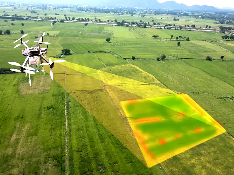
GIS technology is an excellent tool to monitor crop health. Let’s get to know how GIS gathers the required data for farmers through satellite imagery, remote sensing and aerial surveys. Below we will also share how the obtained data can help identify several problems such as nutrient deficiencies, diseases, etc.
Satellite imagery, remote sensing and aerial surveys are powerful tools to not only monitor crop health but also help track several changes in crops. This can include the change in the color of a certain crop, its growth patterns, etc. The obtained data helps understand which areas of the land are under stress due to drought or disease. Such changes in the crops are not visible to the naked eye.
However, by utilizing modern tools and technology, farmers cannot only detect nutrient imbalances and diseases well before time, but they can also make informed decisions to stop crops from dying.
Want to Make Smarter Farming Decisions?
GIS Navigator provides precise data to help you reduce waste, cut costs, and boost efficiency.
📞 Schedule a Call | 📩 Email Us | 💼 Get a Quote Now
Soil Analysis and Land Suitability
One of the advantages of incorporating GIS into farming practices is that it enables the creation of detailed soil maps. This can happen by thoroughly analyzing soil properties like fertility and moisture as well as pH levels. Such detailed and accurate data helps farmers in optimizing crop yields.
GIS utilizes various sensors and satellite imagery to gather data in the form of soil samples. These samples facilitate the process of mapping nutrient levels in a specific piece of land. Once the farmers have identified zones based on how rich or deficient they are in terms of nutrients, they can use fertilizers effectively as, when and where needed. Similarly, farmers can also identify areas that would require more or less water once they have studied soil moisture in detail.
GIS also helps in the effective mapping of soil pH variations. The data then allows farmers to determine the levels of alkalinity in a given land and also make adjustments as per their requirements.
Field Mapping and Land Use Planning
GIS plays a crucial role when it comes to field mapping and land use planning. Let’s discover how farmers can assess and analyze various factors to ensure maximum crop yields.
Having knowledge about factors like elevation, slope and proximity to water resources is crucial for several actions. This can include optimized crop selection, improved irrigation practices as well as reduced soil erosion. When farmers have access to elevation data of a certain piece of land, they can select crops that will grow well in certain temperatures and other growing conditions.
Similarly, farmers can plan out the slopes to ensure a proper drainage system. This can help farmers maintain soil fertility while also reducing soil erosion.
2. Applications of GIS in Agricultural Practices
There are various applications of GIS in agricultural practices. In this part of the article, we would like to briefly explore the applications and see how they enable farmers in multiple ways.
Precision Farming
In order to initiate precision farming, farmers must have access to field-level data that is not only highly detailed but also accurate. Once they have that data, they can take various decisions considering several factors such as optimized use of water, fertilizers as well as pesticides.
Do you want to know how does all of that happens? The answer lies in the efficient use of GIS technology. The data-driven approach provided by GIS allows farmers to ensure that all resources are used effectively.
Turn Data into Growth with GIS Navigator!
From precision farming to risk management, GIS empowers smarter agriculture.
📞 Schedule a Call | 📩 Email Us | 💼 Get a Quote Now
Irrigation Management
GIS has become an indispensable tool for effective irrigation management.
What GIS technology does is that it allows for the creation of irrigation plants across different areas of the field. Farmers can identify the water needs and then optimize the water usage throughout the crop cycles. Through soil moisture mapping, farmers can ensure that they are applying the right amount of water in different parts of the field.
By doing so, both overwatering and underwatering of the fields can be avoided.
In addition to that, farmers can also study the weather and climate patterns in detail to efficiently schedule irrigation plans. By utilizing GIS in irrigation management, farmers make sure that there is no or reduced water waste and that their crops will have better yields to offer.
Pest and Disease Management
GIS can also help in pest and disease management. Let’s discover how GIS helps in predicting pest outbreaks. Here, you will also get to know how GIS allows for careful monitoring of the spread of diseases based on historical and real-time spatial data.
GIS helps process past records of pest infestations and then offers insights to prevent the infestation from occurring. The obtained data is highly detailed as farmers can predict where and when pest infestations can occur.
One of the best features of GIS technology is that it allows for real-time monitoring which helps the concerned professionals track all that’s happening in their fields and then make informed decisions.
The decisions can be related to optimizing temperature and humidity. Moreover, farmers can also track disease activities and take action accordingly.
Yield Prediction and Planning
By using GIS technology in agriculture, farmers can also forecast crop yields by analyzing a number of factors. Those can include soil conditions, weather data as well as the past performances of a certain crop.
When farmers have access to that kind of data, they can streamline several activities effectively.
For example; while facilitating the process of forecasting crop yield, GIS allows for a better planning of harvest. And then, they can also schedule other logistics as well such as distribution and storage of yields as per their production, etc.
3. Supporting Technologies for GIS in Agriculture
Now, we would like to talk about the supporting technologies for GIS in the field of agriculture.
We are sure that once you guys have read this part, you will be able to understand how these technologies enhance the use of GIS in agriculture. In addition to that, you can also learn how GIS has proved to revolutionize farming practices and will continue to do so in the future as well.
Satellite Imagery and Remote Sensing
Satellites are capable of capturing high res. images of vast areas without any difficulty.
One of the advantages of utilizing satellites to gather farm data is that the information will be comprehensive, allowing farmers to view, track and analyze several developments.
Satellite imagery allows for careful planning of various operations as it helps gather data such as field health, identify stressed zones and also monitor environmental changes. GIS is a great tool for monitoring vegetation health. By making the most of the Normalized Difference Vegetation Index (NDVI), farmers can detect which crops are healthy and which might require extra care.
Moreover, GIS also enables farmers to carefully track crop growth in detail.
By having access to such data, farmers can also compare the various stages of crop growth and know whether the crops are growing fine or require certain changes in the farming practices such as a revised irrigation plan or even nutrients for that matter.
When it comes to the use of remote sensing in agriculture, we must mention here that these sensors are designed to share real-time insights that tell farmers how well their crops are growing. In addition to that, these sensors can also alert them in the context of deficiencies, infestations and outbreaks.
With GIS Navigator’s satellite image processing, you can monitor crop health across large areas, identify stressed zones, and address issues proactively.
Finally, the remote sensors help farmers carry out detailed field condition assessments. By having access to such detailed data, farmers are in a better position to work on an optimized irrigation plan. Also, they can prevent soil erosion by ensuring that their farming practices are not harmful to the environment.
Drones and UAVs
Satellites, when used for monitoring crops, they gather data that is not in high resolution for the concerned professionals to analyze things in detail. However, by using drones and Unmanned Aerial Vehicles (UAVs), farmers, agriculturists, etc. can not only gather high res. data but they can also make the drones fly extremely close to the ground.
This enables farmers to have access to highly detailed and accurate data in the form of images, etc. We must also mention that the farmers can gain information on specific pieces of land by using drones and UAVs.
Let’s discuss how drones and UAVs facilitate several processes in agriculture. Starting with high-resolution imagery; the drones that are used to capture data are designed to collect highly detailed images of the crops and soil.
By having access to the land that is deep, farmers, etc. can monitor problems and work towards their healthy solutions well before time.
Thanks to GIS and other modern equipment, the lives of the farmers are much easier than they used to be in the past. In addition to that, drones also offer localized mapping, facilitating small farmers to analyze pieces of land more closely. We must mention here that this is something which is not possible with satellites.
4. Benefits of GIS in Agriculture
GIS technology offers several benefits across a number of fields. However, in agriculture, the use of GIS is nothing short of instrumental as it allows data-driven decision-making from the time when the first seed is planted to the efficient market supply of yields.
Here, we would like to share the benefits of GIS in agriculture in detail – allowing you to know how GIS has an essential role to play in improving farming practices.
The result can be magnificent given that all the stakeholders are ready to explore GIS to its maximum potential.
Increased Productivity
By integrating GIS into farming practices, farmers can easily optimize all their resources. How it happens is something you would like to know!
What GIS does is that it offers field-level data to its users which is crucial to understand various factors in a specific piece of land. This can include soil conditions and moisture conditions.
In addition to that, crop health can also be monitored, and preventive measures can be taken as and when required. Various farming operations can be easily streamlined with the use of GIS in agriculture such as when water and fertilizer should be applied.
Moreover, farmers can also perform these applications as per the specific needs of the land, ensuring that they do not overdo or underdo anything.
By making the most of GIS in agriculture, farmers can enjoy higher levels of productivity. In addition, precision farming also enables the stakeholders to boost their crop yields while also making sure that their agricultural lands are free of inefficiencies.
Sustainability and Resource Conservation
GIS technology is an excellent tool across a number of fields mainly because of the fact that it allows for sustainable decision-making. In agriculture too, GIS plays a crucial role when it comes to sustainability and resource conservation.
Let’s get to know how it does all of that in this part of the article!
GIS enables farmers to analyze the areas of land that require extra attention as compared to the land that is healthy otherwise. This allows for precise irrigation and other farming operations.
For example, farmers can detect early signs of disease and pest infestations and work towards the resolution effectively and efficiently. When they have access to such detailed information, they can ensure that the resources are being used where needed.
Since GIS in agriculture prevents the overuse of all sorts of resources, integrating it into farming practices will prove to be beneficial both in the short and long term.
Cost Efficiency
In today’s age and time, staying within a budget while also performing all the necessary operations has almost become a luxury. However, with the use of GIS, farmers can incorporate practices that are cost-efficient.
For example; GIS technology enables farmers to reduce operational waste. Moreover, they can also prevent the overuse of resources after thoroughly analyzing the fields. When they have access to such detailed data, they cannot only minimize the use of heavy machinery but can also utilize other resources efficiently.
In short, GIS is a tool that guides the entire thing while increasing profitability and keeping the operational costs on the lower side.
Climate Resilience
In agriculture, GIS allows for adapting to the changing climate conditions more effectively. It offers various tools that help monitor soil health and weather patterns and also keep the environmental conditions in check. And the best part is that all of this happens in real time.
Moreover, farmers are in a better position to adjust their planting schedules and make other informed decisions by studying the historical and current data related to climate conditions.
Lastly, GIS also enables farmers to stay put in case of a natural calamity such as floods by analyzing flood-prone areas in detail. Having access to such crucial information allows for precautionary measures such as revising irrigation plans, moving livestock to a safer area and more.
Looking to Enhance Agricultural Efficiency?
GIS Navigator helps you track, analyse, and manage resources with ease.
📞 Schedule a Call | 📩 Email Us | 💼 Get a Quote Now
5. Challenges in Implementing GIS in Agriculture
While there are several benefits of GIS, there are a couple of challenges that can arise in implementing GIS in agriculture.
Let’s have a look at the challenges and how they can impact the effectiveness of GIS in farming practices, especially for small-scale farmers.
Data Accessibility
Farmers who own small pieces of land, especially in remote areas, can face difficulty when it comes to accessing high-resolution spatial data in real time. Since the use of satellites, drones, etc. can be a a little too expensive for farmers, they are usually not able to have access to data that is detailed or accurate. In such a situation, making the most of GIS becomes nearly impossible.
Cost of Technology
All good things come with a price tag and GIS is one of those things. While it is understandable that to enjoy the effectiveness of GIS in agriculture, farmers have to invest considerable amounts of money, the cost of technology can restrict them from seeing what GIS can do for them.
Obviously, small-scale farmers do not have a lot of money to invest in GIS, so they choose to utilize and rely on traditional farming practices.
Training and Adoption
No doubt, GIS is an excellent tool to streamline a number of farming operations but it’s also important for farmers to know how to use this technology. Now, this is another challenge that can directly impact the effectiveness of GIS.
Since specific technical skills are required to make the most of GIS, many farmers can decide to stick to conventional farming methods as they would find it difficult to adopt modern, better farming practices.
6. How We(GIS Navigator) Assists in Revolutionizing Agricultural Practices
If you are a farmer who wishes to enjoy GIS to its full potential, we would like to share that GIS Navigator will help you do that by offering tailored guidance throughout the process. Want to know how we can assist you in revolutionizing agricultural practices? Let’s explore;
Comprehensive GIS Solutions for Agriculture
Our tailored services will empower you with comprehensive GIS solutions that can help you perform several actions. This can include monitoring crop health in real time, developing effective irrigation plans and making informed decisions as and when needed. With our detailed guidance and advanced GIS tools, you cannot only select optimal crops but can also boost their yields for the greater good.
Cost-Effective Solutions for Farms of All Sizes
Regardless of the scale of your agricultural lands, we offer solutions that are not just reasonably priced but also scalable. At GIS Navigator, we will help you optimize all types of resources including water, labor and more. By teaming up with GIS Navigator, you can significantly reduce your operational costs while increasing profitability.
Training and Support
We understand the importance of having the right skill set and enough knowledge to make the most of GIS tools in your farming practices. To ensure that you can get the most out of your investment in GIS, we offer training and support that is essential for you to improve your current farming practices. You will find our team right by your side throughout the training and implementation process without any difficulty.
Climate Resilience and Sustainability Planning
If you are one of those farmers who are truly passionate when it comes to making sustainable farming-related decisions, then you are already at the right place. GIS Navigator aims to educate our partners to build resilience against climate variability.
It does so by providing you with predictive analysis as well as planning which is solely based on spatial data. By incorporating the obtained information, you can plan and manage your operations well while also ensuring that your crops are doing more than just okay.
Optimize Your Farming Strategies with GIS!
Leverage GIS Navigator to make data-driven decisions and improve sustainability.
📞 Schedule a Call | 📩 Email Us | 💼 Get a Quote Now
Conclusion
GIS has proven to revolutionize the field of agriculture through precision farming. By helping farmers increase efficiency and build resilience to climate change, GIS not only helps boost crop yields but is a powerful tool for making sustainable farming-related decisions.
To sum it up, we would like to mention that investing in GIS at this point might seem like a huge upfront cost, especially if you are a small-scale farmer. However, we can also assure that the long-term benefits can easily outweigh the initial costs and the time that you might have to spend learning how GIS works.
If you have come this far and require a little more convincing to implement GIS in your farming practices, then contact us or give us a call right away. One of our team members will efficiently answer all your questions and help you know how GIS technology can enhance your agricultural operations.


