Satellite Image Processing
Make smart decisions with high-precision satellite image processing carefully tailored to your project’s needs.
Several industries majorly rely on satellite imagery to perform actions such as infrastructure planning and environmental monitoring. However, the processes of accessing, processing and extracting insights from satellite imagery can be time-consuming and might also require hiring a team of experts to perform the desired tasks. Using traditional methods to extract data comes with several challenges such as lack of precision, inaccurate data and so on. The inability to deliver reliable data on time can pose multiple issues for the project teams resulting in conflicts which can impact the project outcomes.
We enable clients to witness streamlined workflows, allowing them to make informed decisions for business growth and the betterment of communities.
Solution
1. Multispectral & Hyperspectral Image Processing
We leverage multispectral and hyperspectral imaging to gather information across various wavelengths. This allows for capturing a comprehensive analysis of the Earth’s surface, sharing insights into soil composition, water quality, vegetation health and more. Our expert advice enables our clients to thoroughly assess environmental factors and work on resource management. This also allows for effective resource management while keeping environmental factors in check.
2. Land Use Classification
We leverage high-resolution satellite imagery to ensure the accurate categorization of land cover types like forests, urban areas and water bodies. Our Land Use Classification services facilitate various applications such as urban planning, environmental conservation efforts and more. We also deliver precise classifications to our partners for making informed decisions regarding land use. This helps ensure long-term sustainability throughout a project’s lifecycle.
3. Vegetation Health Monitoring
At GIS Navigator, we enable the process of accurate vegetation health assessments by thoroughly analyzing satellite images. Our expertise helps detect crop stress, diseases and infestations well before time, allowing for effective risk mitigation and avoiding wastage of resources. Our clients feel empowered when they can optimize their agricultural productivity while enhancing food security with our vegetation health monitoring services.
4. Change Detection
We enable several industries to detect changes in the landscape as this information is crucial for accurate environmental monitoring, strategic urban development, etc. Our services allow for tracking changes in land use along with other major developments in the environment. This information helps clients understand the effects of both natural and human activities performed on certain land and also make informed decisions.
5. Urban Growth Tracking
We leverage satellite imagery to carefully map and analyze urban expansion. With our efficient Urban Growth Tracking, we identify trends in urban sprawl. We also track how population density changes over time. Such valuable insights enable investors and developers to devise strategic urban development plans while making sure that the developments will align with environmental and social needs and requirements.
6. Climate Change Monitoring
We leverage advanced technologies and modern tools to perform accurate Climate Change Monitoring. Through our precise satellite image processing, we help track climate patterns and sea-level rise along with vegetation shifts as and when required. We offer actionable insights to support climate research, enabling policymakers to introduce sustainable environmental management practices. This allows for staying one step ahead in the game, ensuring that the stakeholders are making data-driven decisions.
Industries We Serve With Our
Satellite Image Processing Service
Our Satellite Image Processing services enable several industries to perform required actions through data-driven insights that improve efficiency while also incorporating innovative and sustainable practices.
1. Mining & Natural Resources
Satellite image processing is essential for various resource exploration and environmental management in mining and natural resources. We leverage advanced imaging techniques that help identify hidden mineral deposits and assess vegetation cover. Our services are tailored to empower companies by optimizing their extraction processes.
2. Environmental Monitoring & Agriculture
We offer detailed satellite imagery analysis to enable our clients for sustainable agricultural practices. Our services cover monitoring vegetation health, land use changes and analyzing climate impacts. Stakeholders utilize data-driven insights to boost crop yields and conserve while also conserving natural resources.
3. Urban Planning & Development
Our services empower urban developers to manage city growth and future development plans. We deliver data on urban expansion, land use patterns along with infrastructure changes. This data is crucial for the creation of sustainable urban environments; allowing for strategic and sustainable future developments.
4. Historical Preservation & Cultural Sites
Accurate historical preservation & cultural sites require detailed information. We enable clients to monitor and document changes in landscapes that occur with time. To understand the impacts of those changes, we offer comprehensive data, allowing effective site preservation. This enables sustainability and supports preserving the integrity of historic areas.
Looking for Professional Approach and Quality Services?
Our Approach
Detailed Initial Consultation
After arranging detailed consultation calls, we craft tailored strategy plans to meet your project’s specific requirements.
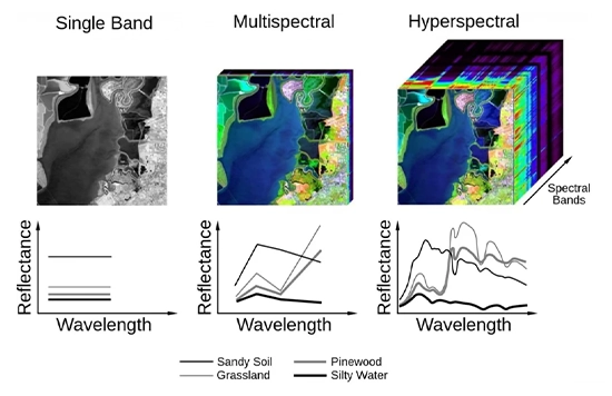
Data Processing
Our team of experts carefully processes satellite images to deliver results that perfectly match your objectives.
Continued Support
You will find us right by your side as we ensure that the obtained data seamlessly aligns with your specific requirements.
Recognized by the Best
We deliver smart, reliable GIS solutions on time, helping our clients meet deadlines, avoid costly penalties, and achieve success
Contact Us
Your Trusted Partner for Advanced GIS Solutions.
Our experts are ready to guide you in finding the perfect GIS solutions for your needs. Let’s discuss your project today!