Urban Planning & Development
Transforming Geospatial Data into Practical Solutions for Urban Development

Urban planning is essential to build cities that work for everyone, but modern challenges like crowded neighborhoods, limited green spaces, and growing infrastructure demand smart solutions.
Geographic Information Systems (GIS) help urban planners make data-driven choices, turning complex information into practical steps that improve daily life.
Our GIS services, from monitoring urban growth to assessing land use, provide real-time data on what cities need to grow responsibly. With GIS, planners can balance new development with environmental care and community priorities, paving the way for vibrant, sustainable cities.
How GIS Navigator Helps
Plan Cities That Work for Everyone
Spot the Best Development Opportunities
Protect the Environment While Growing
Get Solutions Designed for
Your Needs
How GIS Navigator Helps
Plan Cities That Work for Everyone
Spot the Best Development Opportunities
Protect the Environment While Growing
Get Solutions Designed for Your Needs
Smart Cities Start with Smart Data
Shape cities that work for everyone. Use GIS for smarter zoning, infrastructure design, and growth management.
Looking for Professional Approach and Quality Services?
Relevant Services for Urban Planning
Data Integration & Analysis
Combining data on demographics, environment, and infrastructure helps urban planners fully understand their cities.
GIS simplifies this process by visualising complex information, helping planners identify trends such as overcrowding or the need for green spaces. For example, combining traffic data with new housing developments allows planners to assess potential congestion issues.
Our solutions simplify collaboration, ensuring strategic plans align with community goals and regulations.


Site Selection Analysis
Site selection analysis is crucial for urban planning, ensuring that development projects are placed in the most suitable locations. GIS-based site selection outperforms traditional methods by providing detailed spatial analysis and real-time data, helping planners quickly assess various factors like accessibility, environmental impact, and community needs. This approach generates suitability maps visually highlighting optimal sites, enabling faster, more informed decision-making. Using GIS, planners can enhance project success and ensure developments align with community priorities, ultimately fostering sustainable urban growth.

Land Use & Zoning Analysis
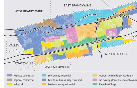
GIS is essential to land use and zoning studies because it allows planners to thoroughly assess spatial data. Using GIS, planners can visualise zoning borders, examine land-use compatibility, and evaluate the effects on infrastructure and resources. By weighing community needs against environmental sustainability, this methodology encourages more intelligent urban development decision-making. GIS provides insights into transportation systems, conservation areas, and population patterns by overlaying data, guaranteeing that zoning regulations support both preservation and growth goals.


3D City Models for Urban Planning
3D GIS models provide urban planners with realistic city simulations, supporting effective visualisation of complex urban landscapes. These models enable stakeholders to visualise projects interactively, clearly representing their effects on buildings, infrastructure placement, and compliance with zoning regulations.
Visualising development scenarios helps planners assess impacts on transport, green spaces, and facilities, enabling balanced decisions. GIS enhances proposals, meets regulations, and boosts community engagement for more accurate urban planning.

Utility Mapping (Sewer, Power)
GIS-based utility mapping for electricity and sewer networks improves infrastructure management and urban planning with remarkable accuracy. Planners use GIS to visualise and analyse utility networks to avoid overlaps, optimise routes, and efficiently manage resources. GIS facilitates accurate asset placement, risk reduction, and maintenance scheduling by mapping subterranean utilities, electrical grids, and sewer systems.
This technology enables quick emergency responses, reduces utility costs, and minimises disruptions, fostering a safer, sustainable community.


Visualisation of BIM Data in GIS
Combining 3D building designs with geographical data clearly explains your planning and construction projects. This approach helps evaluate environmental impacts, supports better planning decisions, and simplifies project management from start to finish. GIS lets you see how elements fit together, identify infrastructure needs, and understand construction limits.
Additionally, this connection fosters teamwork by allowing real-time updates, ensuring smooth coordination among diverse project teams.

Urban Growth Tracking
GIS-based urban growth tracking empowers planners to monitor and analyse changes in land use, population density, and city expansion over time. By staying ahead of growth trends, cities can effectively plan for essential housing, transportation, and infrastructure needs. This proactive approach supports sustainable resource management and green space preservation and enhances investment opportunities. With GIS, urban planners, and real estate investors can anticipate future developments, ensuring that growth aligns with community goals and regulatory standards. Embracing this service demonstrates a commitment to responsible development and thriving communities.


Zoning Compliance Analysis
GIS-based zoning compliance analysis is crucial for urban planners to ensure development projects meet local zoning laws and regulations. GIS tools can highlight potential conflicts or necessary adjustments early in the planning process by mapping zoning districts and overlaying planned projects. This early detection helps avoid costly rework, as planners can address issues before they escalate. Furthermore, by simplifying the compliance review with community standards, GIS zoning analysis speeds up approval times, allowing projects to move forward more efficiently while ensuring alignment with legal requirements.

Contact Us
Your Trusted Partner for Advanced GIS Solutions.
Our experts are ready to guide you in finding the perfect GIS solutions for your needs. Let’s discuss your project today!
