Environmental Monitoring & Agriculture with GIS Solutions

The agriculture and environmental monitoring sectors face significant challenges in managing resources sustainably. Climate change affects soil damage, pest outbreaks, and unexpected weather make it harder to grow crops and keep ecosystems healthy.
Farmers have to adjust according to these challenges, while environmental departments face difficulties with land use planning and managing flood risks.
Innovative solutions are essential to ensure food security and protect ecosystems, making geospatial technology a vital tool for enhancing agricultural practices, boosting agricultural yields and resource management. By leveraging GIS, stakeholders can effectively address these challenges, promoting sustainability and resilience in agriculture and environmental monitoring.
How GIS Navigator Helps
Precision Agriculture: Optimises crop monitoring and resource usage.
Boost yield: Boosts yield while crop monitoring.
Flood Risk Assessment: Models flood risks for better planning.
Data Integration: Combines geospatial data for clear assessments.
How GIS Navigator Helps
Precision Agriculture: Optimises crop monitoring and resource usage.
Boost yield: Boosts yield while crop monitoring.
Flood Risk Assessment: Models flood risks for better planning.
Data Integration: Combines geospatial data for clear assessments.
Looking for Professional Approach and Quality Services?
Data-Driven Solutions for a Sustainable Future
Protect the environment while improving land use. Get accurate GIS data for sustainable farming and natural resource management.
Relevant Services for This Industry
Vegetation Health Monitoring
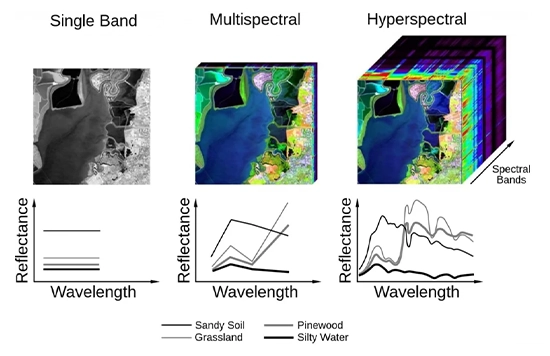
GIS-driven vegetation health monitoring enables precise tracking of crop growth, identifying areas affected by pests, drought, or disease Using multispectral and hyperspectral imaging, GIS provides insights into the health of vegetation across large agricultural areas, allowing for timely interventions that improve yield and resource efficiency. This service helps farmers and environmental managers respond quickly to threats, optimise fertiliser and water use, and maintain healthier ecosystems. Using this proactive approach, GIS Navigator supports sustainable agriculture and effective environmental monitoring, delivering the data to make informed, impactful decisions.


Land Use Classification
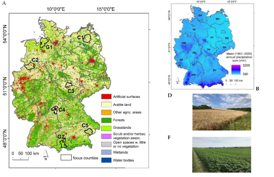
Land use classification through GIS technology helps stakeholders categorise and monitor land for agricultural, urban, and conservation purposes. GIS Navigator analyses satellite imagery and other geospatial data and provides accurate, up-to-date land-use maps, allowing for better planning and regulation. This service is critical for agriculture, where understanding land changes can inform crop rotation and resource allocation. Environmental monitoring aids in managing protected areas, mitigating human impact, and supporting sustainable land management and development practices that balance growth with conservation.

Climate Change Monitoring
Climate change impacts agricultural productivity and environmental health, making accurate monitoring essential. GIS Navigator’s climate change monitoring tools enable precise tracking of temperature shifts, rainfall patterns, and other climate variables that affect farming and ecosystem stability. By mapping these trends, GIS supports adaptation strategies that help farmers mitigate risks and increase resilience. Environmental agencies also benefit by using this data to develop conservation strategies, prepare for extreme weather events, and support policy-making efforts. Through this service, GIS Navigator aids in understanding and adapting to climate challenges with data-driven insights.


Multispectral & Hyperspectral Image Processing
Multispectral and hyperspectral image processing enables detailed analysis of land and vegetation health by capturing data beyond visible light. GIS Navigator’s image processing technology helps identify subtle variations in crop health, water stress, and soil quality, providing actionable insights to improve farm management. This service allows for precision agriculture practices, where targeted treatments can be applied based on specific needs. In environmental monitoring, these images help detect ecosystem changes, support conservation efforts, and inform land use planning. It’s a high-resolution approach to understanding and managing environmental and agricultural resources.

Change Detection
GIS-based change detection tracks transformations in land, vegetation, and water bodies over time, offering essential data for agricultural planning and environmental protection. By comparing satellite images from different periods, GIS Navigator identifies shifts in land use, crop patterns, and environmental health, supporting proactive management. This service is vital for farmers adjusting to seasonal changes and regulators monitoring deforestation and other impacts. With this data, GIS Navigator empowers users to make timely adjustments, improve sustainability, and protect both agricultural and natural resources from adverse changes.


Water Flow & Flood Simulation
Accurate water flow and flood simulations provided by GIS technology are essential for managing water resources and mitigating flood risks. GIS Navigator’s models simulate water movement through agricultural fields and environmental areas, helping stakeholders plan for irrigation needs and flood protection. This service benefits farmers by optimising water usage and predicting flood-prone zones, thereby safeguarding crops and infrastructure. Environmental managers rely on these simulations to maintain healthy ecosystems and prevent water-related damage. Through data-backed simulations, GIS Navigator supports resilient planning against water risks.

Flood Risk Modeling
Flood risk modeling leverages GIS data to predict potential flood zones and assess impacts on agriculture and surrounding ecosystems. GIS Navigator’s tools analyse terrain, rainfall data, and historical flood patterns to create models that assist in disaster preparedness. For farmers, this helps protect crops and investments by enabling proactive measures, while environmental agencies use it to safeguard natural habitats. This service is invaluable in areas with frequent flooding, offering insights that support better land use planning and risk management strategies, thus minimising damages and ensuring sustainability.


Drainage Basin & Watershed Delineation
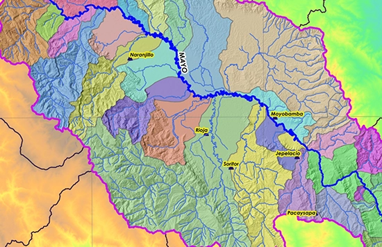
GIS-based drainage basin and watershed delineation is crucial for water resource management in agriculture and environmental monitoring. By mapping these areas, GIS Navigator helps determine how water flows across landscapes, guiding irrigation planning and flood prevention efforts. Farmers benefit from understanding water distribution and catchment areas, optimising water usage and soil management. Environmental agencies also use this service to preserve aquatic ecosystems and manage pollution sources effectively. It’s a responsible water management tool supporting sustainable agriculture and conservation initiatives.

River Morphology Monitoring
River morphology monitoring using GIS tracks changes in river courses, sediment deposits, and erosion patterns. This service helps farmers and environmental managers understand how rivers impact nearby agricultural fields and ecosystems. GIS Navigator’s analysis informs interventions that prevent soil erosion, manage riverbank stability, and protect farmland. For environmental conservation, it aids in preserving natural water flows and biodiversity. River morphology monitoring is a proactive solution that ensures sustainable agricultural practices and ecosystem health in areas influenced by river dynamics.


Geospatial Data Integration
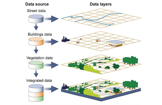
GIS Navigator’s geospatial data integration combines various data sources—satellite images, weather data, and soil maps—to offer comprehensive environmental assessments. This integrated approach helps stakeholders see the full picture, enabling more informed decisions in agriculture and environmental management. Farmers can use this service to optimise planting strategies and resource use, while regulators benefit from a holistic view of land and water resources. Data integration through GIS is essential for making accurate, coordinated decisions that improve productivity, conserve resources, and ensure environmental sustainability.

Contact Us
Your Trusted Partner for Advanced GIS Solutions.
Our experts are ready to guide you in finding the perfect GIS solutions for your needs. Let’s discuss your project today!
