Boundary lines decide what you control, what you can build, and who carries the risk at the edge. They affect ownership, access, utilities, planning status, and future maintenance. GIS helps by making those edges explicit, comparable, and testable against records and constraints. It will not remove uncertainty, but it will show you where it matters and what to do next. By the end, you should be clear on which UK datasets are evidential, how to avoid common interpretation errors, and how to move from a best-available working line to a boundary that can support legal, planning, and construction decisions.
Why Boundary Mapping Drives Project Risk
Boundary mapping looks deceptively simple: draw a line around a site and get on with design. In practice, unclear edges are a fast route to cost, delay, and disputes, especially as projects move from feasibility into planning, procurement, and construction. GIS helps by making boundaries explicit and comparable against constraints, rights, and assets, but it cannot resolve uncertainty by itself. The key is knowing what each source can prove, then choosing a proportionate route to certainty for the project stage.
A common issue is treating every line as equally authoritative. An architect’s red line, a Land Registry title extent, an OS feature, and a surveyed fence can each be valid in context and still disagree. GIS is where those differences surface early, which is what you want. It is cheaper to identify uncertainty up front than to discover it during land negotiations, a utilities diversion, or a planning validation challenge.
Cost and Programme Impacts of Boundary Uncertainty
Boundary error often looks small and becomes expensive once tasks are sequenced. A few metres can change unit numbers, drainage strategy, visibility splays, ecological buffers, or land take. That triggers redesign, fresh surveys, and renewed stakeholder engagement.
On programme, uncertainty creates decision paralysis because teams cannot trust the base plan. Often the first material delay is not design complexity, it is waiting for clarity on what land is controlled, what can be accessed, and what third-party rights exist. GIS helps by quantifying “at risk” areas and flagging where edges interact with constraints, rather than debating the entire perimeter in the abstract.
Ownership, Access and Liabilities at the Edge
Boundaries are where responsibilities blur: who maintains a fence, who owns a verge, where shared access starts and ends, or which side of a ditch is included. These details matter because liabilities frequently sit at the edge, notably for drainage, retaining structures, trees, and highway interfaces.
In GIS we often map operational and legal boundaries separately. An operational line might follow a maintained hedge or gate, while ownership may differ. Making that distinction visible helps planners, land agents, and engineers place risk with the right party. If your project involves adoption, asset transfer, or maintenance obligations, boundary clarity is an asset management issue as much as a land issue.
Utility Corridors, Easements and Wayleaves
Many schemes under-allow for what runs near or across the edge: utility corridors, easements, wayleaves, and maintenance access rights. These can constrain foundations, tree planting, SuDS, and future phases, even if they are not obvious on a planning portal.
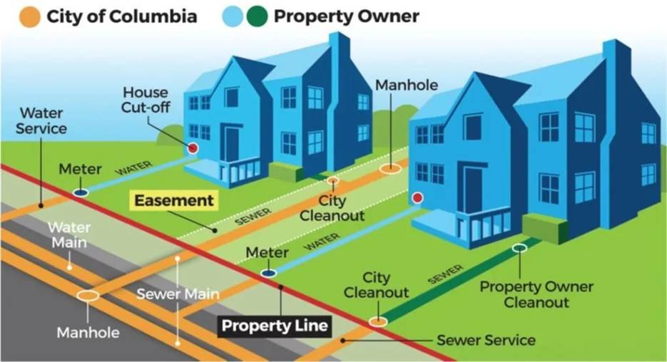
GIS is especially useful for mapping buried constraints as corridors, not thin lines, reflecting working widths for protection, access, and diversion. The corridor you can design around may be wider than the corridor you can prove from records. Set out what is assumed, what is evidenced, and what will be verified later, for example through PAS 128.
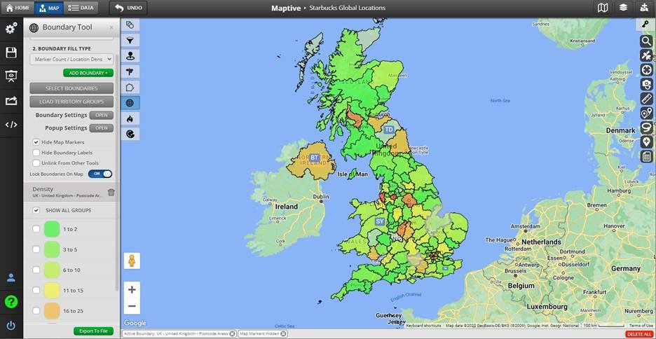
UK Boundary Datasets and What They Prove
UK projects usually combine several baselines. Problems arise when one is assumed to be “the boundary” and the rest are treated as context. Each dataset has a purpose, scale, and legal weight. A robust workflow starts by asking what you are trying to evidence: ownership, occupation, responsibility, or the extent of a planning application.
Early stages need a defensible best-available line and a clear statement of confidence. As projects mature, move from mapped interpretation to survey-backed and legally defined extents. GIS brings inconsistencies into focus so they are actionable: where title diverges from physical features, where highway adoption limits affect access, and where third-party rights clip a proposed red line.
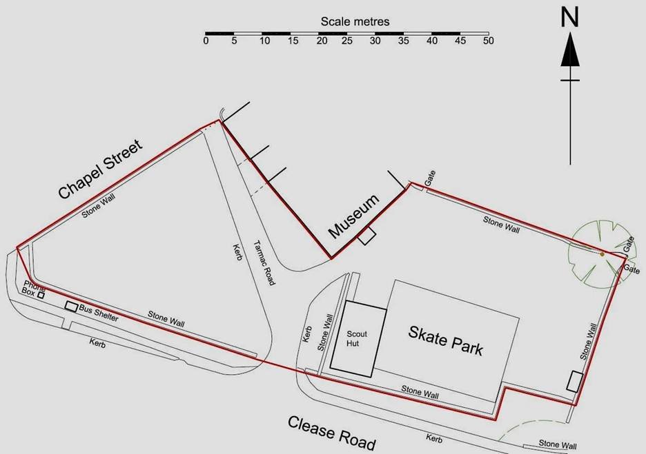
Land Registry Title Plans and General Boundaries
Land Registry title plans usually reflect the general boundaries principle: they show the general position of the boundary, not an exact surveyed line. Line thickness, map scale, and the base mapping influence how precisely the edge can be interpreted.
In GIS, title plans are excellent for identifying titles and structuring land referencing, but they are not engineering geometry. If you need certainty for setting out works, agreeing land take, or resolving disputes, you need a different route, typically a measured survey and legal advice. GIS should manage the evidence chain by keeping title extents, deeds and surveys linked, versioned, and traceable.
Ordnance Survey Mapping and Feature Interpretation
Ordnance Survey mapping is the visual backbone of many boundary plans, but it represents topographic features, not ownership. A fence, wall, hedge, or building line may coincide with a legal boundary, or it may not. Problems arise when teams digitise a boundary from OS features without checking legal intent, especially in rural areas where features move.
In practice we use OS features as context and for alignment. When someone says “the boundary is the ditch line,” the next question is which side and what evidence supports that. If you interpret boundaries from OS, record the logic and confidence so it can be challenged and improved later rather than hard-coded into the base plan.
Highways, PROW and Third-Party Rights Records
Sites often adjoin highways, PROW, and other access rights. These are rarely held in a single clean dataset. Local Highway Authority adoption limits, PROW definitive map alignments, and permissive path agreements each affect what can be gated, altered, or relied on for access.
GIS brings these layers together and highlights conflicts between your site extent or access and recorded rights. Add “status” fields, for example adopted or unadopted, definitive or claimed, confirmed or unconfirmed, so decisions reflect record reliability. If you are new to spatial workflows, a quick read of what GIS mapping is helps with how lines and boundaries are represented and analysed.
Planning and Zoning Constraint Mapping
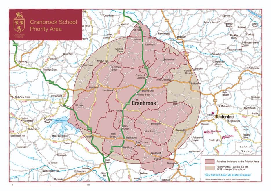
Planning is where boundary mapping becomes a validation and decision requirement. The red line, blue line, ownership certificates, and location plan all rely on a credible spatial extent. If the boundary is wrong, you lose time at validation, invite neighbour objections, or assess impacts for land you do not control.
Constraint mapping is also where GIS earns its keep. It overlays local plan designations, environmental and heritage layers, flood risk, and access to show what the boundary means in planning terms. The line defines which policies apply, which consultees are triggered, and what mitigation might be required.
Red-Line Plans and Application Validation Needs
A planning red line should include the full extent of development, including access, visibility splays, drainage outfalls, landscape works, and construction compounds where relevant. A common pitfall is drawing it tight around buildings, then discovering essential elements lie outside, forcing a redraw and re-consultation.
Treat the red line as a controlled GIS dataset with versioning. If it changes, downstream products such as constraints plans, areas, and reports must update consistently. A “quick tweak” can create inconsistencies unless the spatial data is managed properly.
Local Plan Designations and Constraint Layers
Local plan layers vary in quality and update frequency. Some are robust GIS datasets; others are scanned polygons digitised with variable accuracy. Distinguish policy boundaries from physical features, as policy lines may not follow fences or roads.
A good constraints map shows the designation, its source, and any interpretation limits. For example, a settlement boundary traced from a PDF may be indicative until confirmed. If you are doing meaningful overlay and impact analysis, it is worth being comfortable with spatial analysis so you can sense check results and understand how small shifts change intersections.
GIS Tests for Capacity, Access and Impacts
Once the boundary is set, GIS can run early tests that inform options: developable area after buffers, access feasibility, proximity to receptors, and policy compliance. These are not final answers but they help teams avoid obviously constrained options.
The main risk is false precision. A feasibility capacity number based on uncertain boundaries and coarse constraints creates misplaced confidence. State assumptions, include sensitivity to boundary shifts, and be clear what needs survey or specialist input. GIS is strongest at comparing options, less reliable when forced to give a single definitive number too early.
Utilities and Underground Constraints Integration
Utilities are where boundary mapping meets delivery risk. A line that ignores service runs, chambers, or easements can pass a planning check and still be unbuildable without costly diversions. The goal is not just to gather plans, but to integrate records, understand uncertainty, and decide what to verify.
GIS is a sensible coordinator because utilities data arrives as PDFs, CAD, shapefiles, scans, and schedules. A managed layer can record source, date, owner, confidence, and contact for each dataset. This pays off when budgets are challenged and you need to show why a diversion was or was not allowed for.
PAS 128 Surveys and Geospatial Control
PAS 128 improves confidence by detecting and, where applicable, verifying buried assets. Even so, outputs depend on geospatial control: how the survey was tied in, which coordinate system was used, and how results were delivered.
A frequent issue is mixing PAS 128 with other datasets without checking alignment and units, creating phantom conflicts or missing real ones. Agree the coordinate reference system, accuracy, and deliverable format before the survey, then run basic QA in GIS as soon as data arrives. If your work sits between records and survey, the overview in GIS in surveying is a practical reference.
Combined Above-Below Ground Constraint Models
Often the most useful output is a combined constraint model: boundaries, topography, access, above-ground assets, and underground constraints with confidence bands. Designers can then see where the hard parts of the site really are, especially at edges where services enter or where third-party land is involved.
Combining datasets does not remove uncertainty, it exposes it. A strong GIS deliverable separates recorded, surveyed, and assumed utilities, and shows protection zones where relevant. Version control matters: once a diversion is agreed or a survey refines a route, update the model so the team does not keep designing to old information.
Quality, Certainty and Delivery Approach
Boundary work succeeds when teams agree what “good” looks like. Is the deliverable a planning-ready red line and constraints overlay, a land referencing plan for negotiation, or a construction set-out boundary? Each needs a different level of certainty. Trying to deliver survey-grade certainty from desktop data is where budgets burn.
Treat certainty as incremental. Start with best-available evidence, use GIS to highlight where uncertainty matters, then invest in survey or legal steps where it changes decisions. This protects programme and avoids wasted effort.
Survey and Legal Routes to Defined Boundaries
When you need a defined boundary, GIS is one part of a larger process. A measured topographic survey establishes occupation on the ground; legal interpretation and, if needed, agreement with adjoining owners resolves ownership. Determined boundary applications or boundary agreements are legal routes, not GIS outputs.
GIS should organise and present the evidence: align deed plans, surveys, and title extents; highlight discrepancies; and produce plans that support legal and stakeholder conversations. If a boundary is likely to be contentious, plan for it early.
Common GIS Errors and QA Checks
Most boundary errors are avoidable. They stem from misaligned datasets, wrong coordinate systems, digitising without snap rules, or using a plausible line without recording the source. Another common issue is mixing mapping at different scales and assuming equal precision.
A light but disciplined QA process includes checking coordinate reference systems, verifying overlay alignment against control points, reviewing topology for gaps and overlaps, and ensuring every boundary has a source and date. If sharing data across consultants, include a simple readme and symbology so the line is not reinterpreted later.
Scoping Deliverables, Effort and Responsibilities
Good scoping keeps boundary work finite. Agree which decisions the boundary must support, which datasets will be used, and what unknowns will remain. Be explicit about who owns which risk: client, GIS team, surveyor, solicitor, or utility coordinator.
If you want one practical checklist to align expectations, include these scoping points:
- purpose of the boundary (planning, land negotiation, construction, asset transfer) and required confidence level
- boundary sources to be used (title plans, OS mapping, survey, highways/PROW records) and how conflicts will be handled
- deliverables (GIS layers, PDF plans, metadata, change log) and update process when the red line changes
If you are weighing a structured GIS workflow against ad hoc drawings, browsing the broader advantages of GIS can help you frame what to ask for when you speak to a consultancy. When you are ready, share a sample of your current boundary and constraints information and ask what level of certainty is realistic at each stage.
Conclusion: Certainty Is Earned, Not Drawn
A boundary line is only as reliable as the evidence behind it. GIS makes that evidence visible, aligning titles, features, constraints, and rights in one place but it cannot substitute for a measured survey, a legal interpretation, or an agreement with an adjoining owner when those are what the decision actually requires.
The practical discipline is proportionality. Apply desktop-grade confidence to feasibility, survey-grade certainty to construction, and legal definition where disputes or adoptions are in play. Conflating these stages is where projects lose time and money, not at the point of drawing the line, but at the point of relying on it for something it was never built to support.
Start with a clear statement of what the boundary must prove and for whom. That single question will scope your data, your QA, and your budget more usefully than any methodology framework.