Location is more than an address it’s a story. With geographic information systems (GIS), marketers can turn address data into powerful narratives. By layering customer locations, demographic traits, and behaviour patterns, GIS gives marketing teams a clear view of who their audience is, where they live, and how they move. This allows campaigns to speak directly to people on their street, in their city, where it matters most.
What is GIS in Marketing?
GIS stands for geographic information systems. It merges maps with data to show relationships tied to location. In marketing, GIS helps businesses visualise customers, discover patterns, and pinpoint where their message resonates most.
By using mapping tools, marketers go beyond age and income. They uncover where customers shop, their daily routines, and their travel routes, all in visual maps that guide marketing efforts.
Why GIS and Marketing Are a Perfect Pair
GIS supports marketing across the entire campaign lifecycle:
- Market Research & Segmentation – GIS helps identify zones where target customers live. It segments audiences geographically based on lifestyle, interests, and economic factors. Satellite imagery can enhance demographic profiling.
- Site Selection for Stores or Events—It analyses foot traffic, competitor presence, and customer density to determine where to open new branches or host events.
- Geotargeted Advertising – Brands can focus their ads on specific areas where the audience will most likely respond.
- Personalised Messaging – Marketers can deliver timely and relevant offers using location and behavioural data.
- Campaign Analysis & ROI Tracking – GIS tools allow businesses to see which regions responded best to a campaign, enabling data-backed improvements.
Real‑World Applications of GIS in Marketing
Retail Brands
Retailers use GIS to understand customer distribution and send location-based offers. For example, promotional messages may appear on mobile apps when users are near a store. This kind of proximity-based marketing increases store visits and sales.
Telecom Providers
Telecom companies track service demand and customer clusters. GIS helps them identify high-growth areas, improving their ad targeting and service coverage planning.
Explore More: GIS for Telecommunications Utilities
B2B Companies

In the B2B sector, GIS maps help sales teams visualise client locations, manage sales territories, and plan outreach in high-value zones.
Explore: Uses of GIS in Business
Healthcare and Public Awareness
Public health campaigns use GIS to deliver messages in regions with low service access or low engagement. This targeted approach improves public response rates.
Benefits of GIS in Marketing
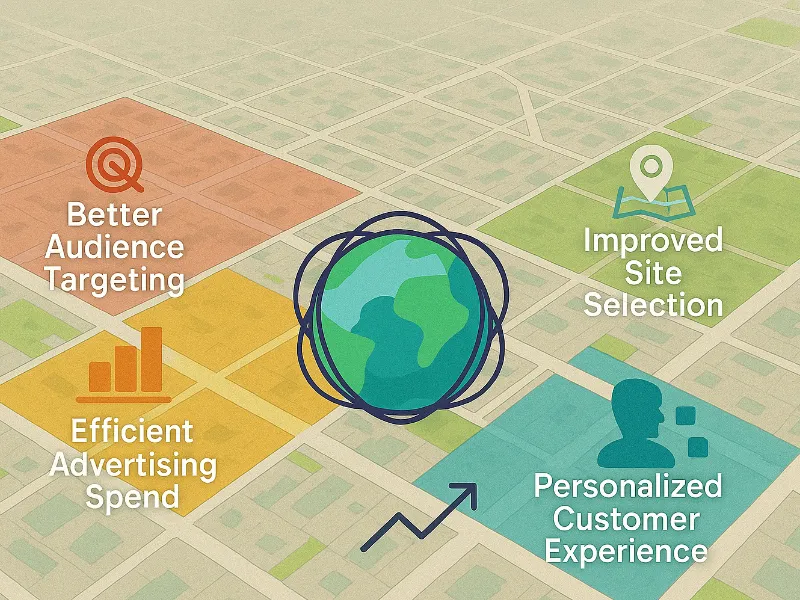
Better Audience Targeting
With GIS, businesses can identify geographic patterns in consumer behaviour. This helps group customers not just by who they are but by where and how they live. Marketers can create more tailored campaigns that speak to specific neighbourhoods or regions.
Improved Site Selection
Instead of choosing store or event locations based on assumptions, GIS provides data on foot traffic, nearby competition, and accessibility. This reduces the risk of poor investment decisions.
Efficient Advertising Spend
Marketers can deliver ads only in areas where they expect higher conversion, reducing waste and improving return on ad spend. Instead of a national campaign, a business might focus only on high-opportunity areas identified by GIS.
Personalised Customer Experience
Offers, promotions, and communications can be delivered based on local events, weather, or store availability. This real-time, location-based engagement leads to more meaningful customer interaction.
Smarter Campaign Analysis
By comparing customer activity before and after a campaign across different regions, GIS allows businesses to track what worked and what didn’t. Marketers can then refine their future campaigns with more precision.
Traditional Marketing vs GIS-Driven Marketing
Traditional marketing decisions are often based on broad assumptions and generic demographics. This can lead to wasted resources and campaigns that miss the mark.
GIS-driven marketing, on the other hand, is grounded in location-based data. It reveals where customers actually are, how they behave, and which areas offer the most growth potential. Every decision, whether choosing where to advertise, open a store, or host an event, is backed by data rather than guesswork.
This shift means fewer mistakes, better targeting, and higher overall returns on marketing investments.
Industry Use Cases
Retail
Brands use GIS to plan store expansions, refine online targeting, and improve logistics. Mapping customer density and competitor presence makes every move more strategic.
Financial Services
GIS helps banks decide where to place ATMs or branches. It also supports localised promotions for credit cards, loans, or savings plans.
Telecommunications
Service providers use GIS to identify underserved areas and match advertising efforts to potential coverage upgrades.
Healthcare

Public and private healthcare providers use GIS to plan outreach campaigns, locate clinics, and boost engagement in low-access areas.
Education and Non profits
Organisations targeting youth, students, or underserved populations use GIS to visualise school locations, community resources, and campaign reach.
GIS supports many other industries beyond marketing. Explore our post on the different industries that are using GIS.
Key Considerations When Using GIS for Marketing
- Data Accuracy: Poor-quality or outdated data can mislead campaigns. It’s essential to source updated and verified data.
- Data Privacy: Marketers must comply with all regulations concerning the use of location data, especially when tracking individuals.
- Training and Adoption: Not every team member may be familiar with GIS tools. It is key to choose simple platforms that offer support.
How GIS Navigator Helps Marketing Teams
GIS Navigator supports businesses by providing:
- Custom maps with layered data such as footfall, income levels, and competitor locations.
- Easy-to-read dashboards for campaign planning and monitoring.
- Target zone suggestions based on customer density and movement patterns.
- Visual tools to track campaign success by geography.
Our platform is designed to be user-friendly and adaptable. Whether you’re a retailer launching a product or a telecom provider planning service rollouts, GIS Navigator turns your location data into actionable marketing strategies.