Flood Risk Analysis
Stay one step ahead with our accurate flood risk analysis that will help you reduce risks while also protecting communities and natural ecosystems.
Floods and earthquakes can cause wide-scale damage, not just to people but also to livestock, farmland, and critical infrastructure. Without accurate flood risk mapping, communities are left exposed, and the environment suffers lasting harm.
Traditional methods often fail to capture the complete picture of changing water patterns and ground movements. This makes it difficult to plan ahead or respond quickly when disasters strike.
What’s needed is a clear, reliable approach that helps identify risks early and guides timely action. Without it, the chances of protecting lives and reducing disruption remain low.
Our flood risk analysis services are built to help you manage these challenges. With the right tools, you can prepare better, respond faster, and protect what matters most.

What We Offer:
1. Flood Risk Modeling
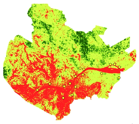
Our flood risk modeling services are designed to help you assess flood hazards with precision. We offer highly predictive insights to guide you in protecting assets while building a resilient infrastructure. You will find us right by your side as we enable you to optimise your risk management plans. Avail our services to efficiently develop your strategies and protect the environment.


2. Drainage Basin & Watershed Delineation
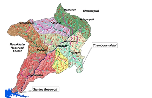
Precise drainage basin & watershed delineation are essential for effective water resource management. Our team of experts will help map hydrological boundaries while delivering valuable insights to support strategic and sustainable development. Through the identification of critical areas, we will empower you to manage water resources in a better way. Get ready to understand flow patterns and work on land use optimisation while safeguarding the natural ecosystems.

3. Water Flow & Flood Simulation
Want to accurately visualise and analyse potential flooding scenarios? Look no further as our water and flood simulation services offer just that. By utilising cutting-edge modelling solutions, we offer predictions on water behaviour. Our accurate predictions help our partners to make data-driven decisions and the actionable insights enable them to stay prepared for flood mitigation while developing sustainable infrastructures for communities.

4. River Erosion & Sediment Deposition Tracking
Our river erosion and sediment deposition tracking solutions help monitor river dynamics and sediment movements. We enable clients to prevent damage in the context of erosions while also supporting riverbank stabilisation. This allows for sustainable land use and strategic development for communities and the environment. Our services are designed to facilitate the process of identifying high-risk areas and ensuring timely interventions.
5. Disaster Risk & Vulnerability Mapping
Our disaster risk and vulnerability mapping helps identify areas that are vulnerable during natural disasters. By integrating hazard data with population density and infrastructure information, we enable proactive preparedness planning. This safeguards both communities and assets and equips stakeholders with valuable data for informed decision-making. Get ready to improve disaster response strategies while making sure that vulnerable communities are safe.


6. River Morphology Monitoring
Wish to stay updated on changes in the river landscape? Look no further as our river morphology monitoring services are designed to help track major and minor shifts in river shapes and behaviors. We also aid in habitat conservation while safeguarding the infrastructures. Our experts are equipped with modern tools that enable them to effectively prevent erosion and safeguard ecosystems.

Check The Flood Risk Before You Build.
From flood risk assessment reports to detailed flood zone maps, you can plan safely and confidently meet planning requirements.

Industries We Serve With Our
Flood Risk Analysis Service
At GIS Navigator, we empower our clients to perform efficient flood risk assessments and stay prepared for natural disasters. This allows for careful improved decision-making while safeguarding the communities and the ecosystems.
Environmental Monitoring & Agriculture
Let’s protect crops and natural ecosystems together with our accurate flood risk analysis! Our services are designed to assist you in water resource management and help stakeholders proactively plan for various challenges. By offering accurate data with precision, we enable improved risk mitigation.
Disaster Management
Improve disaster response with our detailed flood risk analysis. Our solutions enable our clients to accurately predict floods and enhance preparedness through optimised evacuation plans and efficient resource management. This not only empowers our partners but also the communities to minimise potential damage.
Get a free flood risk assessment today!
Our Approach

Initial Consultation
Our team with sit with you to understand your project requirements. After the initial consultation, we offer custom solutions to make informed decisions.

Efficient Risk Analysis
Experts at GIS Navigator will help perform efficient risk analysis allowing your team to monitor vulnerable areas and mitigate risks.

Ongoing Support
Get your hands on detailed reports and receive ongoing support to improve risk management.
Recognised by the Best
We deliver smart, reliable GIS solutions on time, helping our clients meet deadlines, avoid costly penalties, and achieve success

Contact Us
Your Trusted Partner for Advanced GIS Solutions.
Our experts are ready to guide you in finding the perfect GIS solutions for your needs. Let’s discuss your project today!
