Civil engineering is commonly characterised by manual effort, large construction machinery, and essentials such as steel, concrete, and asphalt. However, a subtle but powerful force has changed the essence of civil engineering over the last couple of decades. The integration of digital spatial intelligence especially through GIS in engineering has redefined how we frame, plan, and manage infrastructure in the 21st century. GIS was once limited to cartography and urban planning, but now it has become a vital component in almost every aspect of civil engineering.
From project evaluation at the site to further asset management, GIS allows integration of various datasets such as topography, soil characteristics, land uses, climatic information, and infrastructure layout into one collaborative system. Such integration results in higher design accuracy and increases projects’ efficiency, sustainability, and long-term viability.
Many professionals ask, what is GIS in civil engineering? It’s the application of spatial data analysis tools to plan, design, build, and manage infrastructure more efficiently and accurately.
This technology comes to the fore when it connects spatial data with other pertinent factors. With the GIS, the engineers can see how environmental conditions, construction requirements, and the users interact in real estate projects. Acquiring these perspectives assists engineers in planning for the future more effectively, managing risks, and optimally using funds and materials. In addition, as the complexity of GIS in construction projects grows, GIS becomes an irreplaceable tool for teamwork. It promotes collaboration among engineers, environmental scientists, policymakers, and operations specialists by providing a common understanding of spatial data that is accessible to all.
This article explores how geographic information systems (GIS) revolutionise civil engineering in its core functions, ranging from urban transport optimisation to hydrological modelling, geologic assessment, and post-disaster recovery. Practical examples are used throughout to demonstrate the critical role GIS plays in fostering innovation in contemporary civil engineering, well beyond its status as an auxiliary system. With the rapid spread of urbanisation and climate hazards, as well as the need to preserve infrastructure, the essential role of GIS in civil engineering has become increasingly necessary.
GIS and Civil Engineering
The connection between GIS and civil engineering enables professionals to integrate topographic, environmental, and regulatory data into one shared system, transforming spatial planning into a strategic advantage.
Why GIS Matters in Civil Engineering?
GIS combines various advantages that efficiently respond to the multifaceted and interdisciplinary requirements of civil engineering. These advantages include:
- Visual Integration: Sums up different forms of information to produce an all-around visual representation of the construction environment.
- Enhanced Accuracy: Uses modern and high-definition data to create reliable design and planning strategies.
- Improved Efficiency: Eliminates errors and simplifies the pre-construction analysis phase to be more efficient.
- Cost Optimisation: Prevents potential risks during their early stages, which contributes to avoiding expensive rework and unnecessary resource expenses.
- Regulatory Compliance: Allows early identification of the environmental impact and ensures that all projects are designed to comply with the existing regulations.
These capabilities illustrate how GIS in construction supports safer builds, more accurate forecasting, and better resource use at every project stage.
Applications of GIS in Civil Engineering
Below are the key ways GIS is used in the field of civil engineering. Let’s explore them one by one.
1. Site Selection and Land Use Planning
GIS technology is highly used in civil engineering to enhance the choice of construction sites. Engineers receive a much more comprehensive look at land suitability when using GIS to layer such data as land elevation, soil makeup, flooding risks, permitted uses, and seismic risks than through traditional survey techniques.
GIS empowers teams to:
- Select the most convenient locations for developing large-scale infrastructure projects, such as roads, pipelines, and residential areas.
- Identify and avoid habitats under threat because of environmental or geological dangers.
- Evaluate several sites’ accessibility, zoning, proximity, or distance from basic infrastructure. By using GIS for the initial stages, engineers minimise the risk of future issues and maximise the investment decisions.
2. Transportation Network Design and Traffic Management
Transportation infrastructure profits much from the support of GIS as an integral element for engineering planning and administration, with its massive data requirements.
Using spatial data, engineers can:
- Plot traffic patterns, determine high-risk accident areas, and look at road layout.
- Examine how the environment and the people in the vicinity may be affected by such infrastructure as bypasses or overpasses.
- Reroute traffic in real time to avoid areas affected by construction or emergencies.
Another use of GIS in transportation is to assist the authorities in identifying patterns of deterioration and scheduling routine repairs. Consequently, road safety is enhanced, traffic flow is reduced, and the life cycle of the infrastructure is increased.
3. Water Supply and Drainage System Design
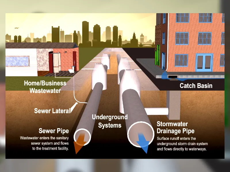
Water resource management must be treated integrally in cities and the countryside. Integration of GIS is critical not only to design but also to implement efficient water supply and drainage systems.
It allows engineers to:
- Model watersheds and catchment areas.
- Predict and map flood-prone zones.
- Apply data on runoff to determine appropriate parameters for pipelines and stormwater retention.
In monsoon- or seasonally flood-prone areas, GIS-based hydrological modelling enhances the resilience and longevity of water infrastructure. To learn more explore our guide on gis in watershed management.
4. Utility Mapping and Subsurface Asset Management
Urban infrastructure requires a sophisticated underground asset network such as power lines, water mains, gas pipelines, and fibre optic cables. It is risky and costly to maintain these systems during construction. This is achieved through a unified, GIS-based utility database that maps subsurface assets.
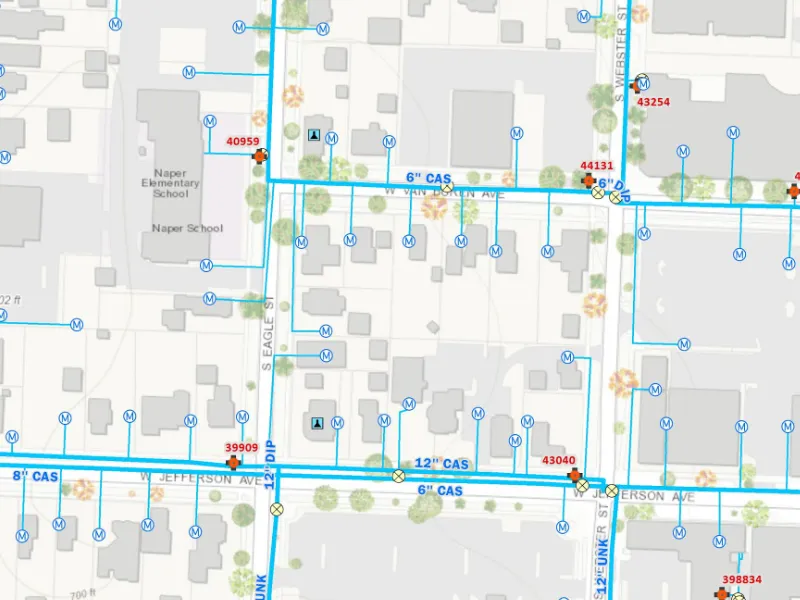
With GIS, civil engineers can:
- Locate the subsurface assets before undertaking excavation work.
- Ensure that there’s easy coordination of various utility agencies and services.
- Reduce the interference with service and construction plans.
As the integrated utility mapping develops, the operational risks are significantly reduced, and safety standards are increased. To dig deeper read our article on gis for utilities.
5. Urban Infrastructure and Land Development

Spatial intelligence is becoming increasingly important within the discipline of urban planning. GIS is an indispensable tool for integrated development, bringing together processes to regulate land usage, protect green areas, control the density of housing, and enhance the network of transport systems.
Applications include:
- Looking at land zones to determine the appropriate space for high-rise development.
- Planning green infrastructure improvements in areas with high heat problems.
- Mapping the location of critical public amenities, including schools and health clinics, to achieve equity regarding access.
GIS technology fosters interdepartmental collaboration and supports coordinated urban planning.
6. Environmental Impact Assessment (EIA)
All major infrastructure projects are subject to environmental regulations.
- GIS enables the creation of predictive models for air and noise pollution.
- Monitoring of protected ecosystems and areas important for biodiversity.
- Carbon footprint data and maps of dispersed pollutants’ presentation and analysis.
These functionalities assist projects in meeting environmental prerequisites, acquiring regulatory approval, and mitigating their environmental impact.
7. Topographic and Terrain Analysis
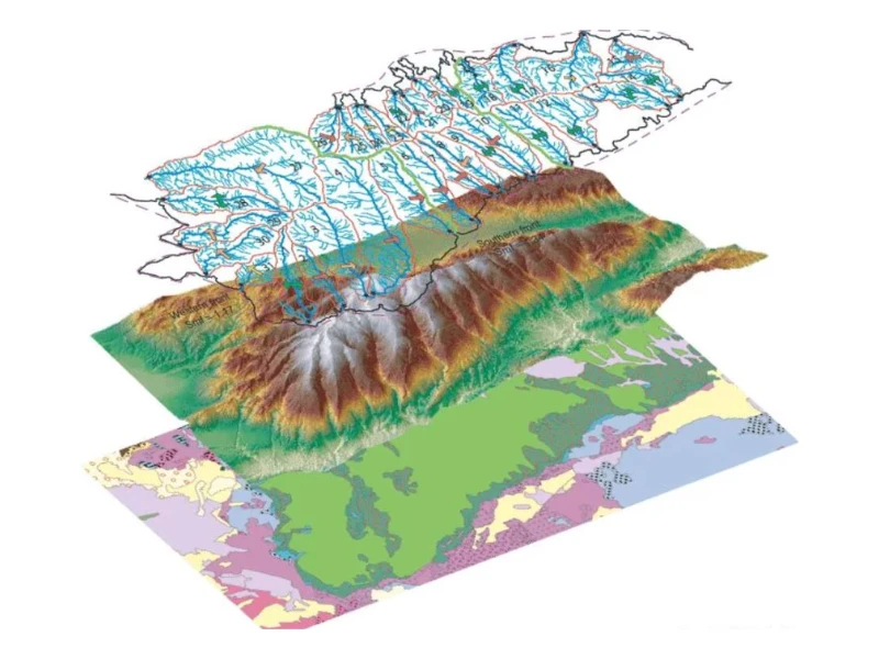
Understanding the terrain is an essential aspect of any building effort. Geographic Information Systems (GIS) depend on Digital Elevation Models (DEMs), contour mapping, and slope analysis to guide engineering decisions.
Engineers can use GIS to:
- Optimise cut-and-fill strategies for grading.
- Prevent construction on slopes in danger of landslides or flooding.
- Plan foundations that have strong engineering considerations for the stability of the terrain.
Detailed topographic analysis reduces the risks of engineering blunders and ensures that construction plans can be safely carried out.
8. Pavement and Road Condition Monitoring
A detailed road network maintenance plan transcends essential manual examinations. GIS-based condition mapping allows agencies to:
- Examine the states of pavements using spatial data.
- Record the development of deterioration and calculate the time for possible future maintenance.
- Schedule maintenance based on traffic flow and identified areas of deterioration.
Data-driven road maintenance protects the public while maximising benefits from infrastructure investments.
9. Bridge and Tunnel Alignment Planning
Projects such as bridges and tunnels must be planned carefully due to the complex nature of the geological, hydrological, and structural risks involved. GIS enables:
- Optimisation of alignment to avoid geostress-stricken areas.
- Subsurface strata representation with corresponding pressure gradients for better understanding.
- Conduct comprehensive analysis of the landscape, aquifer depth, and seismic risk.
Using GIS, minimizing the excavation in geology that may be unstable and simulating stress scenarios makes both design and construction efforts more efficient and safe.
10. Construction Site Logistics and Planning
Spatial aspects fundamentally characterise construction activities on-site. GIS helps optimise spatially:
- Planning of efficient transport routes for both heavy equipment and personnel.
- Organising cranes, organising spaces for materials, and installing safety boundaries.
- Evaluating and controlling spatial planning in highly-packed or inadequately spaced sites.
Such an application of GIS makes project implementation more efficient, wastes less time, and safety hazards are better managed.
11. Disaster Risk Assessment and Emergency Response
Catastrophes such as floods, earthquakes, and landslides will likely destroy infrastructure and jeopardise human safety. Disaster preparedness and recovery are enhanced through the use of GIS by:
- Calculating the probability of disasters in certain areas and the at-risk populations.
- Governing evacuation strategies with the aid of impact modelling.
- Authorities can manage emergency responses in real time using enhanced spatial analytics.
Utilising GIS to strengthen civil defence capabilities and enhance infrastructure systems’ resilience is critical.
You might be intrested in how gis supports disaster response planning.
12. Lifecycle Management and Infrastructure Maintenance
Civil infrastructure nature calls for an all-out commitment to long-term operating needs. Geographic Information Systems (GIS) support the handling of assets during the entire life cycle by linking spatial data with performance logs and inspection routines.
Engineers can:
- Develop digital twins of infrastructure assets for continuous monitoring and analysis.
- Determine required maintenance activities and provide forecasts in line with operational requirements and budgetary considerations.
- Geographic coordinates should be used to track and classify work orders and repairs.
This approach encourages a more proactive and data-driven strategy, improving asset durability and reducing operational overheads.
13. Soil and Subsurface Mapping
Geotechnical factors are crucial in determining the suitability of foundations and the stability of structures. GIS-based soil mapping includes:
- Soil type classification and the determination of each type’s bearing capacity.
- Groundwater and aquifer data integration.
- Previous observations of settlement or earthquake activity.
Such data allows one to choose effective foundation solutions and diminishes the possibility of differential settlement or liquefaction.
14. Documentation, Reporting, and Regulatory Compliance
Documents must be spatially referenced and digitally stored according to modern engineering standards. GIS facilitates:
- Visual reports ensure transparent communication with stakeholders.
- Specific documentation of all inspections, modifications, and approvals during the project.
- Efficient auditing and compliance verification.
This approach simplifies operations and makes managing projects within strict regulatory limits easier.
Build Smarter with GIS Navigator
From detailed site analysis and terrain modelling to utility mapping and post-disaster planning, GIS Navigator delivers specialised services built around the needs of GIS in civil engineering projects. We bring together spatial, environmental, and structural data to give you a clear and comprehensive view of your project landscape—reducing risks, avoiding costly rework, and improving long-term infrastructure performance. Whether you’re planning transportation networks, drainage systems, or urban developments, our GIS services ensure every step is supported by data-backed precision.
Book your free GIS service consultation today and discover how GIS Navigator can turn complex challenges into efficient, spatially informed solutions.


