Water is one of the most important natural resources in society, economy, and the environment. Effective GIS for water plays a crucial role in managing how this resource is allocated, avoiding depletion, and preventing disasters such as floods, droughts, and water pollution. The application of GIS in water resources offers a structured way to analyse spatial data, making water management more accurate and efficient.
Managing GIS in water resources within watershed areas poses challenges such as climate variability, land use change, population pressure, and pollution. This is where Geographic Information Systems step in as essential GIS tools for water planning, enabling better monitoring, modeling, and analysis of hydrological and environmental information. By integrating remote sensing, real-time data collection, and watershed analysis in GIS, we can improve water conservation, disaster response, and pollution control.
This is where Geographic Information Systems (GIS) come into play. GIS is a powerful geospatial technology that helps in the compilation, display, and examination of hydrological and environmental information. It offers maps, models, and spatial data to decision makers, researchers, and engineers to develop appropriate water management policies. Platforms like GIS Navigator support this process by providing tailored geospatial tools that allow users to monitor, model, and manage water systems effectively. Thus, through integration of remote sensing, hydrological modelling and real-time data collection, GIS improves watershed management with respect to water conservation, disaster management and pollution control.
As such, this paper aims at identifying the various uses of GIS in watershed management and also the benefits of using GIS in ensuring the sustainability of water resources in the recent past, characterized by environmental uncertainties.
Need Smarter Water Resource Management?
Use GIS Navigator to monitor water distribution, assess risks, and ensure sustainable watershed management.
📞 Schedule a Call | 📩 Email Us | 💼 Get a Quote Now
Having an Understanding of Watershed Management
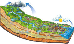
A watershed is a region of land where all precipitation, including rain, snowmelt, and groundwater flow, empties into a shared lake, river, or ocean. Small local streams or big river basins covering several regions might be included in watersheds, which vary in size. To ensure water quality, preserve biodiversity, stop soil erosion, and maximize land use for industry, urbanization, and agriculture, watershed management is crucial.
Watersheds are natural hydrological units that meet essential demands for human well-being and environmental health, as defined by water supply flow patterns, ecosystem support, and the availability of environmental resources. Successful watershed management serves as the key solution in dealing with climate change effects and pollution as well as land abjection and water scarcity. Proper divide management results in flooding of human populations and biological systems and drought as well as habitat degradation and water poisoning.
A comprehensive approach to sustainable water supply management is achieved by combining various disciplines, including hydrology, bionomics, technology, and land-use planning, in watershed management. By offering geographically referenced data, complex mathematical calculations, and predictive modeling, geographic information systems (gis) play a crucial role in this unconscious process and assist scientists, railroad engineers, and policymakers in making well-informed decisions about land and water resources. The long-term viability and adaptability of both human and natural environments are ensured through watershed management, which integrates technology, policy, and the participation of biotic communities.
Applications of GIS in Watershed Management
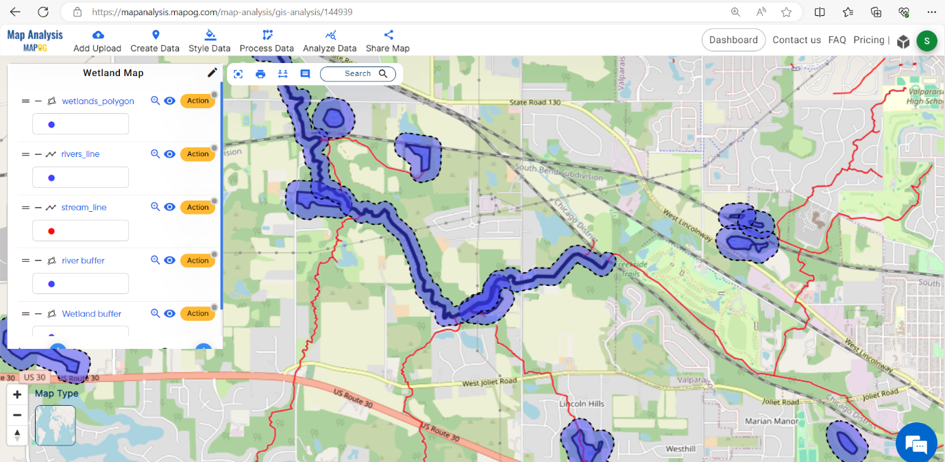
1. Watershed Delineation and Hydrological Modelling
The main purpose of Geographic Information Systems (GIS) for watershed management entails the creation of watershed boundaries through mapping procedures. Digital Elevation Models (DEMs) work together with GIS capabilities to discover stream systems while developing watershed parameters and determining water flow paths and creating sub-watershed regions. Knowledge about the spatial features of watersheds facilitates both efficient water resource planning practices and maintains flood safety along with erosion risk management.
The SWAT (Soil and Water Assessment Tool) model and HEC-HMS (Hydrologic Engineering Center’s Hydrologic Modelling System) tool exploit GIS database information to model watershed hydrological processes that involve runoff development and soil infiltration and water erosion together with sediment movement. The implementation of these modelling approaches helps evaluate the relationship between water resources and land-use transformations and climate alterations and human behavior allowing officials to design enduring watershed management plans.
The combination of rain data with soil information and topographical data makes the forecasting process accurate through GIS solutions. The developed forecasts help create water allocation plans while enabling first warning systems for flood risks and situations of drought. The application of GIS models supports watershed restoration projects that protect aquatic ecosystems in addition to supporting sustainable agricultural productivity.
2. Water Quality Monitoring and Pollution Control
GIS technology is extensively utilized in in water quality monitoring and watershed management for source identification of pollution and estimating the degree of contamination and predicting the spread of pollutants. GIS technology is extensively utilized in water quality monitoring and watershed management for source identification of pollution. A key GIS application in water resources is identifying contaminant sources and analysing their spread across different terrains and land use types. By integrating spatial data such as land use patterns and industrial discharge points with topographical features, GIS allows for tracking the agricultural runoff along with industrial and sewage waste, hence helping to identify sources of contamination.
Authorities use GIS-based models to establish pollution control methods while monitoring wastewater treatment plant performance and planning effective drainage systems. GIS helps policymakers identify critical pollution hotspots through the analysis of seasonal and spatial water quality variations which leads to targeted contamination reduction strategies.
In order to analyse pollution from nonpoint sources, such as diffuse toxins like pesticides and fertilizers as well as urban runoff, GIS technology is essential. Researchers follow pollution routes through watersheds using spatial analysis techniques including overlay mapping and interpolation models, which results in the development of proactive clean up solutions.
3. Flood Risk Assessment and Management
Watersheds are at serious risk from flooding, particularly in urban and agricultural areas. Applications of GIS have been mentioned in designing mitigation strategies, mapping flood-sensitive areas, and assessing flood risk. GIS forecasts flood levels and enhances disaster readiness by utilizing hydrological networks, precipitation patterns, terrain elevation, and previous flood data.
Satellites track precipitation and river level in real time using remote sensing data, enabling better management practices and early warning. In order to determine which areas are susceptible to extreme flooding events, GIS-based flood risk models combine hydraulic simulations, land-use data, and climate change projections.

The implementation of GIS technology for flood management enables a combination of operational methods that support system functions.
- The establishment of flood inundation mapping systems is essential to emergency preparedness.
- Finding appropriate locations for flood mitigation structures such drainage systems, reservoirs, and levees.
- The planning of land-use needs improvement for minimizing new buildings located within flood-prone areas.
- Early warning systems for proactive evacuation planning and resource allocation.
Incorporating GIS technology into climate adaptation initiatives protects both everyday livelihoods and long-term, sustainable flood defences.
Looking for Advanced Flood Risk Analysis?
GIS Navigator helps predict flood-prone areas, improve disaster preparedness, and support effective water planning.
📞 Schedule a Call | 📩 Email Us | 💼 Get a Quote Now
4. Groundwater Recharge and Management Mapping
The long-term preservation of drinking water supplies and irrigation requires sustainable management of groundwater resources because this substance serves as a principal water source. The spatial capability of GIS lets users examine groundwater potential while also showing where recharge happens and tracking what happens to groundwater during extraction.

Geological analysis along with assessments of soil permeability and precipitation records combined with land-use evaluation enables GIS to locate zones suitable for groundwater recharge initiatives by using artificial and natural strategies. Through GIS-based monitoring models decision makers identify groundwater depletion patterns thus allowing them to establish extraction limits and implement water conservation measures.
The following GIS applications serve critically in groundwater management :
- Groundwater experts utilize GIS to track depleted aquifer zones before implementing recharge solutions for these zones.
- Studying information from wells combined with hydrogeological factors helps decision-making processes.
- Sustainable water consumption policies enable the equilibrium of use among urban, industrial and agricultural requirements.
- Predicted contamination risks accompany groundwater flow modelling for maximizing remediation success, a critical use of GIS for water resource management.
5. Land Use and Erosion Management
Watershed health is seriously threatened by erosion, which destroys habitat, reduces soil fertility, and causes sedimentation in rivers. GIS can help map areas prone to erosion by studying variables such as slope steepness, land cover, soil type, and rainfall intensity.
When combined with GIS data, the Revised Universal Soil Loss Equation (RUSLE) provides spatial estimates of soil loss and helps identify areas in urgent need of conservation action. GIS-based erosion models can be used in strategic planning of conservation measures, including contour farming, terrace creation, and forestation.
GIS promotes sustainable land use planning by balancing urbanization, forestry, and agriculture while reducing negative impacts on soil stability and water quality. GIS also monitors land degradation trends to help policymakers ensure sustainable land management.
Related: What is land use mapping?
6. Drought Monitoring and Water Conservation
Droughts threaten water resources, crop yields, and ecosystem integrity. GIS can be used to monitor precipitation anomalies, soil moisture, and reservoir capacity. Predict drought severity and duration using GIS that integrates satellite drought indices, hydrological modeling, and climate data. GIS also helps identify water conservation policy options, improve irrigation practices, and build drought-resistant infrastructure, including rainwater harvesting systems.
Using vegetation indices and soil moisture data, governments and organizations can use GIS to:
- Track agricultural droughts.
- Anticipate water shortages and take proactive preventive measures.
- Plan irrigation as efficiently as possible to maximize water use.
- Develop flexible plans to ensure climate resilience.
- Additionally, using a GIS tool for mining water management, authorities can better plan water extraction strategies and manage scarce water resources during droughts in industrial and agricultural regions.
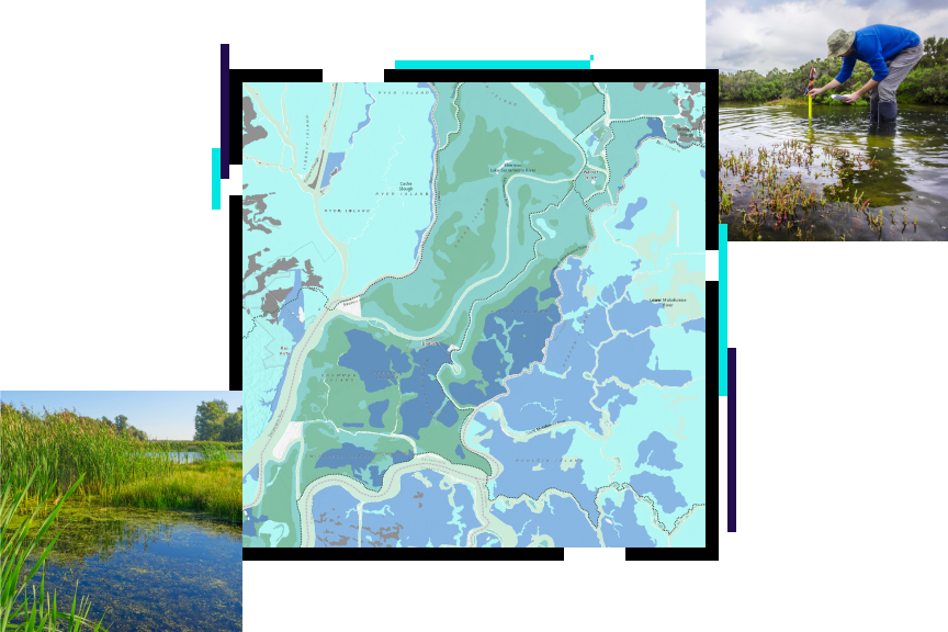
7. Wetland Management and Biodiversity Conservation
Diverse ecosystems are supported by watersheds such as forests, wetlands, and aquatic habitats. We invite you to join us for a discussion on the importance of GIS in biodiversity conservation, including mapping habitat distribution, tracking land cover changes, and assessing environmental threats.
Wetlands form natural filters, improve water quality, control flooding, and provide rich biodiversity. New GIS-based wetland models can help monitor water levels, vegetation dynamics, and human encroachment to better manage these fragile ecosystems.
- Mapping animal migration routes and protected areas to protect habitats is one way GIS is being used to conserve biodiversity.
- Evaluate how land-use change affects biodiversity hotspots.
- Take action to restore degraded wetlands and woodlands in an environmentally sound manner.
- Monitor variations in species distribution brought on by the climate.
Governance and Policy in Watershed Management
Effective governance and policy frameworks, in addition to technology developments, are essential for the successful application of GIS in watershed management. To support GIS applications, governments and regulatory agencies must set up explicit water management regulations, frameworks for exchanging data, and recommendations for sustainable development. To develop a thorough and integrated approach to watershed management, policies should address topics including pollution prevention, conservation initiatives, land-use planning, and disaster preparedness.
Furthermore, the development of GIS technology and its application to watershed management can be greatly aided by public-private partnerships (PPPs). Working together, government organizations, commercial businesses, academic institutions, and local communities can improve data accessibility for well-informed decision-making and speed up the implementation of cutting-edge GIS-driven solutions.
Community Involvement and Stakeholder Participation
Managing watersheds involves tasks which federal authorities must execute alongside the dedicated action of local inhabitants and community leaders. Participation from residents in the region enables conservation projects and pollution control practices to match local social needs as well as environmental and economic requirements.
Through GIS tools communities can achieve empowerment by accessing live environmental data in mapping features and using planning engagement systems. People from local areas can bring crucial information about past water cycles as well as methods for land utilization and climate factors to enhance GIS decisions. Watershed management receives community empowerment through citizen science projects which educate people to monitor water quality also provide reporting channels for environmental concerns while serving as platforms for conservation participation.
Upgrade Your Water Management Strategy with GIS Navigator!
Leverage geospatial data for better decision-making and sustainable water conservation.
📞 Schedule a Call | 📩 Email Us | 💼 Get a Quote Now
Economic and Environmental Benefits of GIS in Watershed Management
GIS investments for watershed management yield extended economic advantages with simultaneous environmental advantages. The combination of spatial analysis and predictive modeling within GIS systems minimizes financial damages which occur from water-related events including flooding and droughts as well as water source pollution. Correct mapping enables economical infrastructure design because resources including dams and reservoirs, and irrigation channels and drainage systems can be deployed properly with optimal efficiency and reduced environmental strain.
GIS technology supports both biodiversity protection through environmental conservation as well as helping prevent water resource decline and soil degeneration. GIS helps develop environmental policies through its ability to identify potential areas affected by deforestation and pollution along with urban development. GIS technology provides improved wetland ecology monitoring capabilities alongside habitat and riparian zone monitoring functions serving to defend natural resources for the upcoming generations.
Conclusion
The creation of GIS tools to support watershed management has become essential for modern times under conditions of climate change and both growing human numbers and dwindling water supplies. GPS serves three essential roles by offering spatial insights about water resource hydrological operations and pollution origins and flood potential and land-use elements.
The integration of AI, remote sensing alongside real-time monitoring systems into GIS technology has elevated watershed management systems by boosting their accuracy and predictive abilities and automation features. Advanced predictions for floods along with groundwater assessments as well as pollution tracking alongside ecosystem restoration become possible because of the more efficient water resource conservation methods.
To develop future water security and biodiversity protection through adaptive climate adaptation measures, governments, researchers, and policymakers must make use of GIS capabilities.
GIS has developed into more than just a tool; it is now necessary for the efficient management of water resources, the protection of natural ecosystems, and the future settlement of difficult environmental and social issues.


