Transform complex utility data into clear, actionable maps for efficient infrastructure development.
The maintenance of society’s backbone depends on the infrastructure and utilities industry. However, aging assets, rising regulatory requirements, and the requirement for effective resource management are some of the major obstacles it must overcome. To maintain service reliability, organisations also need to address challenges associated with integrating large volumes of data from several sources. Ineffective management of these issues might result in expensive disruptions and inefficiencies. GIS Navigator offers creative solutions that assist businesses in overcoming these obstacles, guaranteeing improved infrastructure project planning, administration, and execution to satisfy expanding needs and enhance the quality of service.
How GIS Navigator Helps
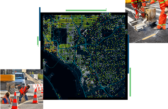
Utility Mapping: Provides accurate mapping of sewer and power networks.
Asset Management: Enables proactive monitoring of infrastructure assets.
Flood Risk Assessment: Facilitates effective drainage and watershed management.
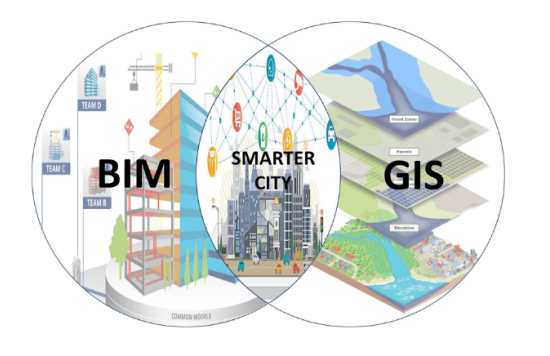
BIM Integration: Enhances project planning through geospatial data integration.
How GIS Navigator Helps
Utility Mapping: Provides accurate mapping of sewer and power networks.
Asset Management: Enables proactive monitoring of infrastructure assets.
Flood Risk Assessment: Facilitates effective drainage and watershed management.
BIM Integration: Enhances project planning through geospatial data integration.
Looking for Professional Approach and Quality Services?
Our utility mapping services leverage advanced GIS technology to deliver comprehensive maps of sewer and power systems. This service is vital for infrastructure planning, as it provides detailed insights into the layout and condition of existing utilities.
By accurately mapping these networks, we help organisations reduce the risk of service interruptions during maintenance and construction activities.
Our mapping also supports compliance with regulatory requirements and aids in disaster preparedness by identifying critical infrastructure locations.
Infrastructure Asset Management
Infrastructure systems’ longevity depends on efficient asset management. With our solutions, businesses can monitor and manage their assets from installation to decommissioning.
Decision-makers can better prioritise maintenance and distribute resources when they have access to real-time data on asset performance and conditions.
Our asset management services also help organisations comply with regulatory standards, guaranteeing they fulfil their legal responsibilities while maximising operational effectiveness.
Drainage Basin & Watershed Delineation
Practical flood risk assessment and management requires understanding watershed dynamics and drainage patterns. Our GIS services accurately map watersheds and drainage basins, offering important information about water flow and flood risk. Organisations may create focused mitigation plans to safeguard infrastructure and communities by identifying important places at risk of flooding. Our services also aid in environmental conservation efforts by highlighting significant ecological areas within watersheds. We give stakeholders the knowledge they need to make wise land use and water management decisions through thorough analysis and meticulous mapping.
Geospatial Data Integration with BIM
The Infrastructure and Utilities industry benefits from improved project planning and execution by integrating geospatial data with Building Information Modelling (BIM).
This seamless data integration allows stakeholders to view and analyse both spatial and design/construction data. It streamlines workflows, reduces errors, and enhances communication among project teams.
By utilising the advantages of both GIS and BIM, organisations may improve project outcomes, allocate resources more efficiently, and make better decisions.
Visualisation of BIM Data in GIS
Visualising BIM data adequately on GIS systems to comprehend the effects of infrastructure projects is essential. Our services help stakeholders quickly understand important insights by converting complex BIM data into easily navigable maps and visualisations.
We assist organisations in evaluating possible hazards and making appropriate plans by clearly depicting the interactions between infrastructure and its surroundings. Stakeholder involvement and communication are improved by this visualisation, which guarantees that all parties fully comprehend the project’s effects.
Contact Us
Your Trusted Partner for Advanced GIS Solutions.
Our experts are ready to guide you in finding the perfect GIS solutions for your needs. Let’s discuss your project today!