Imagine a world in which we are able to precisely and scientifically build sustainable ecosystems, anticipate environmental dangers before they materialize, and track endangered species in real time. This is the potential of Geographic Information Systems (GIS) in wildlife management specifically GIS in wildlife conservation not simply a pipe dream.
GIS makes it possible to follow species in real time, conservationists can learn about threats, habitat use, and migration patterns. It is also essential for mapping biodiversity, tracking the effects of climate change, and effectively managing protected areas. Through GIS in conservation, spatial data for conservation projects is used to map sensitive habitats, identify high-risk zones, and inform long-term ecological strategies. GIS is now a vital tool for protecting endangered species and preserving ecological balance, from locating wildlife corridors to using geospatial intelligence to fight poaching.
GIS is widely used across industries, including urban planning, agriculture, and wildlife conservation.
Looking for GIS Solutions for Wildlife Conservation?
Safeguard Ecosystems with GIS Navigator – Track, Analyse, and Act with Confidence!
📞 Schedule a Call | 📩 Email Us | 💼 Get a Quote Now
GIS-Related Interesting Facts for Wildlife Management
- Researchers first used mapping technologies to study endangered species in the 1960s, when GIS was first used in conservation. Modern conservation techniques were made possible by this early adoption, which also made it possible for scientists to monitor changes in habitat and species distribution over time.
- GIS data used to track habitat loss and deforestation around the world is largely provided by NASA satellites. Conservationists can evaluate changes in forest cover, identify illicit logging activities, and forecast environmental hazards to species with the use of these satellite pictures.
- Monarch butterfly migration throughout North America has been successfully tracked by scientists using geographic information systems. Researchers can pinpoint vital breeding and feeding locations by charting their seasonal travels, ensuring that conservation efforts concentrate on preserving these vital ecosystems.
- Once thought to be extinct in the wild, the Black-footed Ferret was saved thanks in large part to GIS technology. Successful repopulation efforts resulted from the researchers’ identification of optimal reintroduction sites based on habitat appropriateness and prey availability.
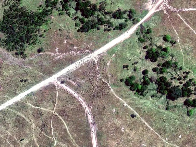
- GIS is used by conservationists in Africa to map the movements of elephants and lessen conflicts between people and wildlife. Experts may create wildlife corridors and put plans in place to stop elephants from intruding on farmlands by examining migration patterns and changes in land usage. This reduces crop damage and conflicts between humans and wildlife.
Learn more about various GIS applications.
Understanding GIS in Wildlife Management
Accurate information on species distribution, habitat use, and environmental concerns is essential for wildlife management. GIS is a cutting-edge technique that facilitates the mapping, monitoring, and analysis of data pertaining to wildlife, playing a central role in GIS wildlife conservation to inform more effective conservation tactics. GIS gives conservationists a strong decision-making tool to preserve biodiversity by combining information from field observations, remote sensing, and satellite photography. This use of remote sensing in wildlife management helps identify habitat loss, monitor land-use changes, and detect threats long before they impact endangered species.
Related: Disaster Management
Using GIS to Track Animal Movements
Conservation depends on tracking the movements of animals. Researchers can gather real-time information on the whereabouts, migration paths, and habitat preferences of species by utilizing remote sensors, satellite tracking, and GPS collars.
- Conservationists can identify wildlife corridors that are crucial for species migration and habitat connectivity by using GIS technologies to visualize this data on interactive maps.
- Examine seasonal migration trends to learn about feeding and breeding habits.
- Determine how habitat utilization has changed as a result of environmental changes, human encroachment, and climate change.
This data assists policymakers in creating plans to reduce confrontations between people and animals and in putting in place wildlife-friendly infrastructure, such as underpasses and overpasses for safe animal crossings.
To ensure the long-term survival of threatened and endangered species, the National Wildlife Refuge System, for example, employs GIS technology to effectively manage protected areas and monitor species populations.
By integrating GPS technology with GIS, researchers can track animal movements in real time.
Discover how GPS enhances GIS applications.
Mapping and Analysing Habitats
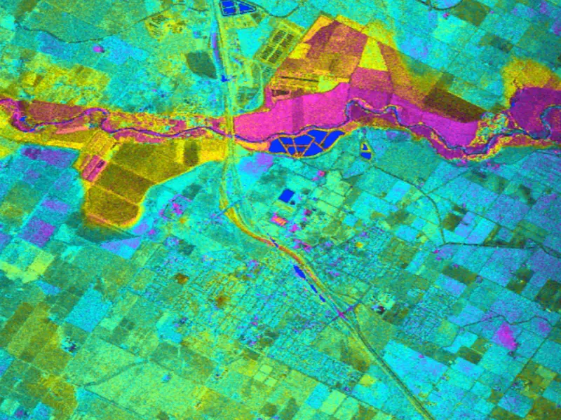
Habitat fragmentation and biodiversity loss result from the ongoing changes in wildlife habitats brought on by urbanization, climate change, and deforestation. Using GIS to create precise habitat maps that emphasize vegetation types, land use patterns, and ecological corridors, conservationists can keep an eye on these changes. A thorough investigation of habitat appropriateness and the effects of human activities on ecosystems is provided by GIS, which arranges various environmental data sources in layers. One of the most impactful uses is GIS for biodiversity mapping, allowing conservationists to track species richness, assess ecological value, and prioritize conservation zones based on spatial biodiversity data.
In order to preserve biological connections, conservationists might use habitat mapping to pinpoint high-priority areas that need to be protected, restored, or wildlife corridors. GIS also helps determine how natural disasters, such as floods or wildfires, affect habitats so that prompt actions can be taken.
The Esri GIS for Wildlife Conservation program demonstrates how habitat mapping enhances land-use planning and species management by facilitating data-driven decision-making to strike a balance between development requirements and conservation efforts.
Assessing Threats to Wildlife
Wildlife encounters multiple threats including illegal poaching together with pollution habitat destruction and climate change. Multiple data sets of geographic location which include field entries and satellite imagery along with remote sensor measurements assist conservationists in detecting and mitigating risks in actual time.
The anti-poaching campaigns together with patrol team deployment make use of GIS technology which identifies areas affected by illegal hunting activities. The implementation of conservation measures takes place in advance through predictive GIS models which indicate areas prone to deforestation thus reducing habitat destruction. The analysis of pollution impacts on wildlife populations depends on GIS monitoring of industrial waste disposal sites and oil spill contamination sources and their subsequent effects on ecosystems.
gracias to Global Forest Watch organizations can perform real-time forest observation by tracking alterations in land usage and monitoring underground timber theft. GIS technology serves legislators in creating conservation plans that protect sensitive ecosystems and implementing environmental enforcement.
Applications of GIS in the Conservation of Wildlife
GIS in Wildlife Conservation and Species Reintroduction Programs
To guarantee a species’ survival and long-term viability, reintroducing it into the wild necessitates meticulous planning. Through the analysis of habitat suitability, prey availability, and hazards from human activities or predators, GIS assists conservationists in assessing possible reintroduction sites. Conservationists can find optimal sites with little human disturbance, suitable food sources, and ecological conditions that promote species recovery by using GIS-based modelling.
One excellent example is the California Condor’s successful reintroduction, in which GIS was crucial in locating safe habitats by charting human disturbances, food sources, and nesting locations. After almost becoming extinct, the condor population has grown thanks in large part to this strategy.
Conservation of Marine Wildlife
By monitoring the movements of sharks, sea turtles, whales, and other aquatic animals, GIS is also used to safeguard marine life. Scientists can lessen human effects on marine ecosystems by establishing fishing regulations and establishing marine protected zones (MPAs) by tracking migration routes and breeding sites. Conservationists can create adaptive management plans by using GIS to examine how habitat loss and ocean temperatures are affected by climate change.
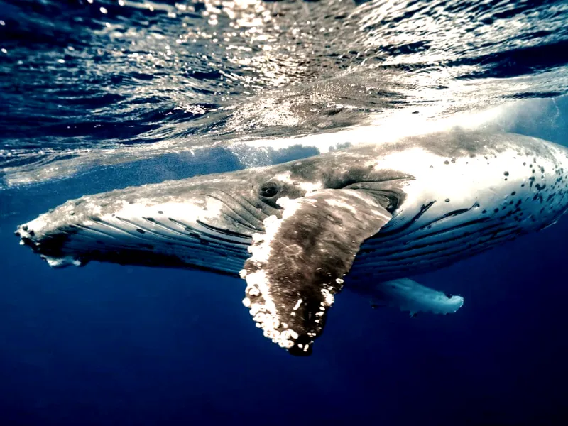
To ensure sustainable fisheries and the preservation of marine biodiversity, the NOAA Marine Spatial Planning Initiative, for instance, employs GIS to manage ocean ecosystems.
Related: The Role of GIS in Disaster Management
Conservation of Urban Wildlife
Given how quickly urbanization is encroaching on natural ecosystems, GIS is essential for reducing conflicts between people and wildlife. To provide safe routes for animals traveling through populated areas, cities utilize GIS to map green spaces, wildlife corridors, and possible conflict zones. In order to decrease collisions between cars and animals, urban planners use GIS to create wildlife-friendly infrastructure, such as green bridges and underpasses.
By tracking and analysing wildlife migrations in North American cities using GIS technology, the Urban Wildlife Information Network assists policymakers in putting conservation plans into action that support wildlife and human coexistence.
Partner with Experts in GIS Navigator for Conservation!
Leverage GIS technology to safeguard biodiversity, optimize conservation strategies, and make data-driven decisions.
📞 Schedule a Call | 📩 Email Us | 💼 Get a Quote Now
Real-World Application of Wildlife Management Using GIS
Case Study: Conservation of Snow Leopard Found in the Himalayas
Snow leopards are tracked in rugged areas through GIS by the Snow Leopard Trust. Wildlife conservations try to record animals and their conflict zones to limit interactions with people.
Case Study: Migration of Elephants in Africa
The migration patterns of elephants are analyzed using GIS which also helps to reduce human-elephant conflict. Examined movement data helps conservationists create protected migration corridors and position anti-poaching units in regions prone to poaching.
Case Study: GIS for Coral Reef Conservation
Changes in sea temperatures and coral bleaching phenomena of the Great Barrier Reef of Australia are measured by remote sensing using GIS. This information helps to take action to preserve marine species diversity and create effective conservation measures.
Case Study: The Use of GIS for Anti-Poaching Activities
When it comes to the illegal wildlife trade, GIS is invaluable. Preparedness against poaching activities is made possible through the mapping of clandestine trade routes and analyzing poaching sites.
Wildlife Protection Solutions is one of the groups that employ GIS to identify and eliminate illegal hunting and poaching of animals in national parks all over the globe.
Advanced GIS Technologies for Wildlife Management
Remote Sensing & LiDAR for Habitat Analysis
Conservationists acquire high-resolution imagery and precise three-dimensional models of a given terrain thanks to remote-sensing technologies, such as Light Detection and Ranging (LiDAR). These technologies aid in assessing the state of habitats, tracking alterations in vegetation cover, and monitoring the effects of deforestation, wildfires, and flooding. Scholars can observe entire ecosystems and predict their deterioration by combining satellite images with aerial scans and actively working to mitigate the damages beforehand. Mitigation allows for habitat restoration and proper management.
Drone Technology for Real-Time Monitoring
Real-time imagery of wildlife populations and their habitats is captured by drones equipped with GIS software and high-resolution cameras. Unlike LiDAR, drones eliminate some of the previous obstacles concerning the protection of endangered species, illegal hunting, or habitat degradation. It is also much easier to track bad practices pertaining to wildlife protection. Drones reach places that are hard to get to on foot in order to avoid impacting wildlife. Aiding with the collection and construction of aerial images also allows for accurate habitat models to be built. This information greatly improves the criteria that guide planning for conservation.
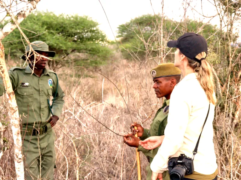
Community and Citizen Science in GIS-Based Conservation
Engaging Local Communities in Wildlife Monitoring
In order to chart traditional animal habitats and safeguard them from dangers like deforestation, mining, and agricultural expansion, many indigenous and local communities actively employ GIS in conservation efforts. actively employ GIS. When paired with GIS mapping, their extensive ecological knowledge offers important insights into the seasonal activities of wildlife and the distribution of species. Involving local communities makes conservation initiatives more successful and inclusive, resulting in sustainable natural resource management.
GIS in Ecotourism and Conservation Funding
GIS-based mapping technologies now use interactive maps to grow their popularity and attract ecotourism visitors to national parks along with wildlife reserves and marine protected areas. Travelers benefit from digital tools by using them to plan their trips track animal migrations and understand conservation projects. Sustainable conservation programs obtain their funding directly from tourism activities that generate revenue. Conservation organizations obtain funding through data-driven reports and visualizations that prove the results of their work since GIS plays this enabling role.
AI-Powered Conservation Predictive Modeling
Artificial intelligence (AI) and geographic information systems (GIS) will transform wildlife conservation by more accurately forecasting future habitat changes and wildlife migration patterns. Large datasets, such as sensor and satellite imagery, will be analysed by machine learning algorithms to identify patterns and dangers before they become serious. Conservationists will be able to take preventative steps like wildlife corridors and habitat restoration to reduce risks by using AI-driven GIS to identify regions of possible habitat loss.
Using Predictive Analytics to Adapt to Climate Change
It is changing ecosystems and species behaviours, climate change is a danger to biodiversity. By simulating environmental changes including shifting temperature zones, sea-level rise, and altering rainfall patterns, GIS will be essential in assisting conservationists in anticipating these effects. Conservation groups will be able to create adaptive management strategies with the help of predictive analytics, guaranteeing that wildlife populations can adapt to shifting ecosystems. Conservationists can save endangered species and shield ecosystems from long-term damage by combining GIS with climate models and acting quickly.
GIS Navigator Advantage
GIS is revolutionizing wildlife management, enabling conservationists to make data-driven decisions that protect ecosystems and biodiversity. With GIS Navigator, you gain access to cutting-edge mapping, analysis, and real-time tracking tools tailored for wildlife monitoring. Take the next step in efficient and sustainable conservation.
So, book your free consultation with GIS Navigator today and see how it can transform your wildlife management strategies.


