The application of GIS in forestry has emerged as a game-changer in the realm of forest management, offering innovative solutions to complex challenges. With forests playing a critical role in biodiversity, climate regulation, and human well-being, sustainable management has never been more vital.
GIS in forestry empowers forest managers, ecologists, and policymakers with precise tools to monitor, analyze, and make informed decisions about forest resources.
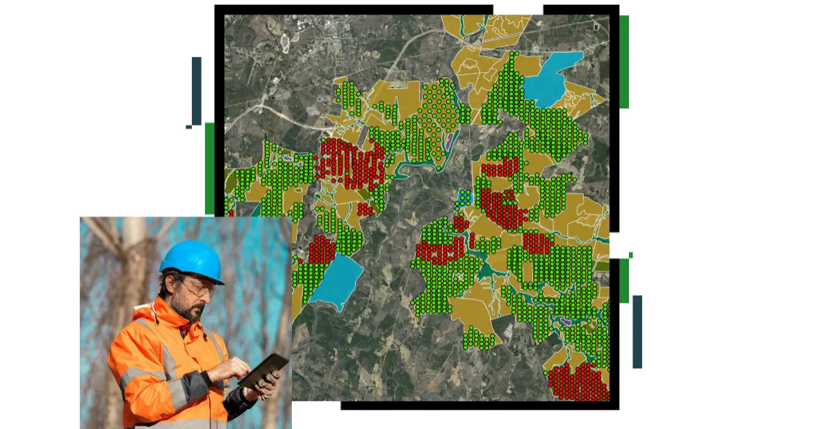
From tracking deforestation and mapping wildlife habitats to optimizing reforestation efforts, GIS and forestry now go hand-in-hand, integrating spatial data with advanced analytics to transform how forests are managed. This article explores how GIS in forest management is revolutionizing sustainability, efficiency, and environmental monitoring in an era of increasing ecological pressure.
Looking for Accurate Forestry Mapping and Analysis?
GIS Navigator delivers precise mapping and analysis for smarter, more sustainable forest management.
📞 Schedule a Call | 📩 Email Us | 💼 Get a Quote Now
One of the most impactful areas of GIS for forestry is in resource management, where spatial decision-making supports sustainable harvesting and conservation goals.
Resource Assessment
Resource assessment activities include:
- Inventorying forest resources available for harvest, fuel, food, recreation, or conservation purposes, along with related data such as topography, soils, roads, and hydrology,
- Monitoring changes that occur to these resources over time, and
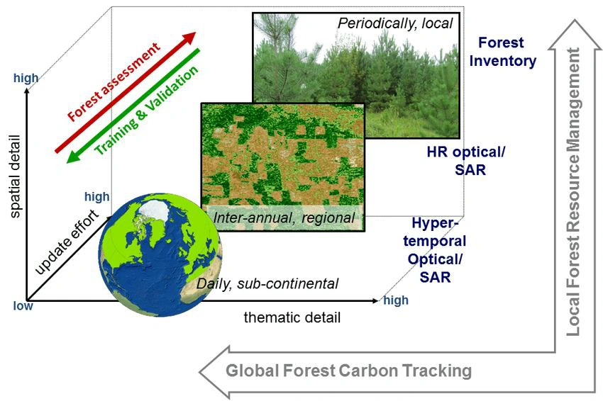
- Evaluating potential land productivity for forest types given certain biophysical and climatic factors. It is in forest resource assessment that other technologies related to GIS, remote sensing, and global positioning systems, make direct and substantial contributions.
Related: Risk Assessment Disaster Management
Inventory
The acquisition of basic inventory data is fundamental to timber management as well as efforts to conserve certain forest ecosystems. Data includes soil type, species type, size, class/stand structure, crown closure, density, and the boundaries of management units (e.g., stands). Once data are entered in a GIS, maps can be displayed showing general species distributions and the area of stands can be calculated).
As the data are updated over time, changes in these distributions can be recorded and analyzed. More customized maps may be created to answer specific resource questions, such as a map that displays the locations of only stressed or diseased species. Creating maps that show the spatial relationships between harvestable tree species and other features such as mills, steep slopes, or even ecologically sensitive riparian areas are possible and useful to managers
Data collection techniques for forest inventories range from selecting sample plots for ground surveys to using topographic maps, remote sensing, and emerging global positioning systems (GPS). While a range of techniques is critical for comprehensive inventories.
Monitoring
While an initial inventory of forest resources stored in a GIS is an important step, changes occur that need to be monitored and recorded. For example, silvicultural activities to manage timber involve complex and specific interventions to control stand structure, stand density, species composition, length of harvest rotation, and to maintain site quality.

Other changes may result from sudden, discrete events or disturbances, such as massive deforestation or pestilence that initiate new development patterns in the affected areas.
Read More: GIS Solutions for Environmental Monitoring
Damage From Pollution and Pests
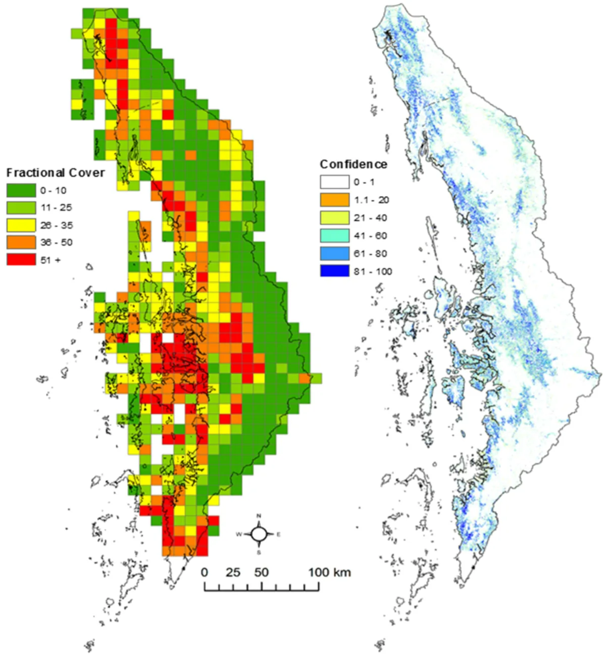
Gradual forest decline is another type of change that can be monitored. Vegetation is sensitive to stress factors associated with changes in moisture, temperature, as well as anthropogenic factors, such as air pollution, forest pests and disease. GIS together with remote sensing offers the means to monitor the magnitudes and rates of decline.
Pests and disease are another source of forest decline. A diversity of insects, fungi, bacteria, and viruses occur in forests and may be beneficial. More destructive pests may be controlled by natural enemies or an unfavourable environment.
In the economics of timber harvesting, small losses due to pests and diseases are generally acceptable; losses that significantly affect timber production are not. Therefore, monitoring pest and disease infestations is a concern for private and national timber interests. GIS and remote sensing are becoming important tools to identify, monitor, and anticipate the spread of infestations.
Identification of the most susceptible areas and stand types focuses and improves monitoring techniques, provides a basis for risk assessment and identifies the probable need and frequency for direct control of infestations in future rotations. Information on the environmental requirements and limitations for outbreaks can improve predictions of where and when future outbreaks will occur and is basic to estimating damage which may be expected with climatic shifts because of atmospheric pollution or global warming effects.
Suitability and Productivity Assessment
Another factor in resource assessment includes efforts to identify biophysical and climatic factors suitable for the regeneration of tree species. This can be important for establishing tree plantations, for afforestation programs, for re-establishing endemic species following severe over-utilization and for timber harvesting.
The information obtained from assessing the potential productivity of a site can be used to manage it for optimal harvest.
This technique may be used with afforestation projects at more local.
Explore More: Geospatial Analysis of Floods
Resource Management
Timber Harvesting
While today’s models are sufficient for defining and developing aspatial management design strategies for wood supply, they lack consideration of the geographic structure of forests and are insufficient for design of wildlife sensitive and operationally, i.e., economically, acceptable management.
GIS has now made it possible to incorporate spatial components into harvest planning and simulation models. In some cases, the modelling capabilities of a particular GIS may be used directly to aid decisions about timber harvesting; in other cases, an external model is linked to a GIS database. These models are typically called Decision Support Systems (DSS) or Spatial Decision Support Systems (SDSS). In any case, the analytical goals are quite similar.
Need Reliable Forestry Mapping & Analysis?
GIS Navigator helps you track deforestation, plan reforestation, and manage natural resources with precision and ease!
📞 Schedule a Call | 📩 Email Us | 💼 Get a Quote Now
Fuel Wood Supplies
The availability of fuel wood supplies for local use is an important forest management issue in many parts of the world. GIS can contribute to assessments of fuel wood supply and demand and offers the potential to predict future needs.
Map production
Forest managers require a wide variety of maps to assist with their daily activities. Plantation maps are most commonly used for location purposes and may contain additional useful information such as roads, rivers, compartment boundaries, planted species, and compartment size. Other features such as topographic features (contours), infrastructure, water points, fire breaks, neighbours and conservation areas may be also included in the map.
Fire management
The effect of fire on forest resources is another important management concern. Management activities include fire prevention, wildlife control, prescribed burning, and post fire recovery actions. The modelling capabilities of GIS have been quite effective in this context. Forest fire managers have used GIS for fuel mapping, weather condition mapping, and fire danger rating. Forest fires have an important influence on the vegetation cover, animals, plants, soil, stream flow, air quality, microclimate, and even general climate.
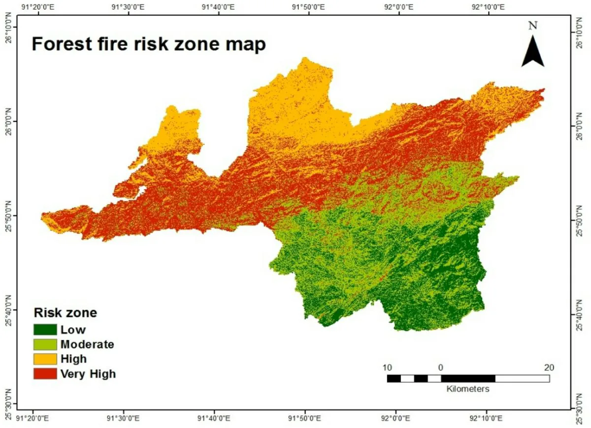
The loss of timber is obvious and so is the damage to life and property. The loss of recreation value of the forest and the destruction of wildlife habitat are also consequences of forest fires.
The key to managing approved burning activities was the ability to anticipate fire behaviour after ignition. Chuvieco et al. explained that fire behaviour models have been developed from fuel models to predict the fire intensity based on factors such as slope, elevation, site exposure, wind speed, relative humidity, cloud cover, temperature, and live and dead fuel moisture. These models are not spatial, however, and are typically used to predict fire behaviour for a fairly large area.
To increase the sensitivity of the fire behaviour models to spatial variability within the park, fire behaviour models were fun with a raster based GIS. With input layers stored in the GIS, its mathematical modelling capabilities, along with selected lookup tables, were then used to implement several fuel and fire intensity models.
By comparing the predicted fire behaviour with actual burn conditions, Wells and McKinsey concluded that the GIS implementation of fire behaviour models was useful in locating potential control areas, planning ignition patterns, and accommodating sensitive areas that would be adversely affected by high fire intensities.
Harvest planning
Good forest management practice requires detailed planning of harvesting activities. Harvest planning activities include the identification of felling directions, extraction routes, depots and sensitive zones such as wetlands. Maps constitute a basic planning tool for these activities.
Other tactical harvest planning functions utilize maps to identify planned felling over a number of years, and to consolidate felling areas and extraction routes thereby permitting the efficient use of harvesting equipment and other resources.
Make Forest Management Easier – Try GIS Navigator!
Discover how our GIS solutions can simplify forest management and boost efficiency. Let’s talk about your needs!
📞 Schedule a Call | 📩 Email Us | 💼 Get a Quote Now
Why GIS Navigator?
Empower your forest management efforts with GIS Navigator, a trusted leader in geospatial solutions.
At GIS Navigator, we specialize in providing tailored GIS services that help you monitor forests, track environmental changes, and optimize sustainability initiatives. Our expertise ensures you have the insights needed to make informed, data-driven decisions for effective forest conservation and resource management.
Book your free consultation and partner with us to navigate the complexities of forest ecosystems and create lasting solutions for a greener future. Connect with GIS Navigator today and let us guide your journey toward sustainable forest management!


