United States Geological Survey (USGS) defines Geographical Information System (GIS) as “A Geographic Information System (GIS) is a computer system that analyses and displays geographically referenced information. It uses data that is attached to a unique location.
1. Relevance to the Utilities Sector
Modern utility sectors are no longer linear but interconnected and dynamic. By harnessing the immense power of GIS, utility companies can cater to this complexity and manage vast networks of assets such as pipelines, power lines, and water distribution systems. Additionally, utility sectors have improved decision-making processes, operational efficiency, and customer service by integrating GIS into their workflows.
With GIS providing spatial context to utility data, the utilities sector is now able to map the infrastructure with utmost precision and accuracy. Furthermore, spatial awareness is proving indispensable for planning, maintenance, and emergency responses. There’s more to it: GIS supports the integration of various data sources, such as satellite imagery, LiDAR, and IoT sensors, creating a comprehensive view of the network.
Facing Challenges in Utility Management?
GIS Navigator provides data-driven solutions to optimize operations, reduce costs, and improve efficiency.
📞 Schedule a Call | 📩 Email Us | 💼 Get a Quote Now
2. Key Applications of GIS in Utilities
Following are the key applications of GIS in utilities;
Electricity Distribution and Management – Network Mapping and Asset Management:
GIS offers a robust solution that caters to the expansion of the electricity network both in terms of complexity and scale. Now electricity utility companies are able to map and manage their assets more efficiently.
With GIS, companies are now creating detailed and accurate maps of utility networks. These detailed maps entail information about the layout of electricity lines, substations, transformers, and other important infrastructure. Furthermore, GIS ensures that utility companies map the network with the information that is most up-to-date and precise. This spatial accuracy becomes extremely valuable when companies are planning for new installations, rerouting electricity during maintenance activities, and locating faults or outages within a network.
The power of GIS goes beyond mapping as it also helps in asset management. With GIS, the utility sector is now able to maintain a detailed and accurate inventory of their assets. Utility managers have now access to critical information such as the exact location of assets, their condition, and maintenance histories. All of it translates into a proactive approach to schedule inspections, maintenance tasks, and plan upgrades.
Outage Management
When it comes to outage management, GIS is helping the electricity sector to accurately address the problem and minimize downtime.
GIS integrates data from multiple resources – such as sensors, smart meters, and customer reports – to help managers perform a swift detection of outages. GIS pinpoints the outage location by analysing the spatial relationship between network components and service areas. Doing so allows it to identify affected regions and visualize them on the map; this helps concerned officials to facilitate rapid response and reduce the time required to fix the problem.
Similarly, GIS further empowers utility managers to manage the response effectively. It enables power companies to prioritize response efforts based on the location of critical infrastructure, customer density, and historical outage data. This prioritization ensures that the most critical areas are addressed first, improving overall response efficiency and reducing the impact on customers.
GIS expedites the repair and restoration efforts, too. As managers have access to detailed maps of the affected networks, they can send field crews to the exact locations of faults and perform necessary repairs. Furthermore, GIS also enables companies to track the repair and restoration progress in real-time. This real-time tracking of restoration efforts ensures that crew staff are doing their tasks effectively. Furthermore, officials can communicate with customers about the status of the restoration process.
Energy Load Management
GIS plays a major role in managing and optimizing energy loads. Utilities companies can now map energy usage across different regions and times, GIS enables officials to identify trends such as peak demand periods and areas with higher consumption. The Power sector uses this spatial analysis to accurately forecast future energy needs, allowing it to plan resources in a more efficient manner.
Energy optimization emanates another benefit: energy waste. GIS is used to pinpoint areas with line losses, outdated equipment, and inefficiencies. Then, this information is used by utility managers to target improvements. With this approach, not only is energy waste reduced but also operational costs are lowered.
Discover how our GIS utility mapping services can optimize your next project. Click here to explore more.
3. Water & Waste Management – Pipeline and Resource Mapping
GIS offers a significant advantage in mapping, monitoring, and maintaining water infrastructures. GIS caters to the growing complexity of the water system and provides a detailed solution to ensure efficient management and operational reliability.
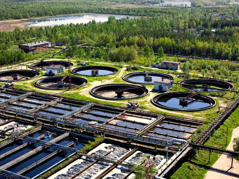
Utilities use GIS to create detailed visual representations of the whole water network. This way, precise mapping is done. Stakeholders integrate data from multiple resources such as satellite imagery, aerial surveys, and field inspections and doing so empowers them to accurately document the following:
- Location
- Size Material
- And, condition of the pipelines.
This GIS-powered mapping is extremely valuable for planning and managing water distribution systems.
When it comes to water flow, GIS streamlines the whole process by providing real-time data and spatial analysis. GIS integrates data from various resources such as flow meters, sensors, and SCADA systems to visualize the flow of water through the entire network. This comes in real-time monitoring and the same enables utilities managers to track water usage and identify fluctuations in flow rates as well. Furthermore, it helps the managers to regularly assess the performance of the distribution system.
Pipeline Management
When it comes to water management, leakage remains a big headache. However, GIS comes to the aid of utility managers and makes the whole leakage detection process more efficient. It does so by aiding in identifying potential leak locations by analysing flow data, pressure levels, and historic leak information.
One of the most significant benefits of GIS in water pipeline management is its ability to detect and address leaks efficiently. GIS helps identify potential leak locations by analysing flow data, pressure levels, and historical leak information. By comparing real-time data with expected flow patterns and pressure readings, GIS can highlight anomalies that may indicate leaks. Additionally, GIS allows utilities to visualize the network in detail, helping field crews quickly locate and repair leaks. This proactive approach reduces water loss, minimizes damage, and ensures that repairs are carried out promptly.
Resource Management
Beyond pipeline management, GIS aids in the broader management of water resources. It supports the analysis of watershed areas, water sources, and consumption patterns. GIS helps utilities plan for future water needs, manage water conservation efforts, and assess the impact of environmental changes on water resources. By integrating various data layers, such as land use and environmental factors, GIS provides a holistic view of water resource management, facilitating sustainable practices and informed decision-making.
Want to Enhance Utility Infrastructure Planning?
Leverage GIS Navigator’s smart mapping technology to streamline asset management and future-proof your network.
📞 Schedule a Call | 📩 Email Us | 💼 Get a Quote Now
4. Pipeline and Resource Mapping -Pipeline Monitoring and Leak Detection
GIS plays a critical role in monitoring extensive gas and oil pipeline networks. By providing geospatial data, it helps operators detect leaks early and locate potential threats, such as environmental hazards or third-party interference. With real-time mapping, GIS can track pipeline integrity and highlight areas that need maintenance or immediate attention, ensuring efficient and safe operations.
Risk Management and Safety Planning
By leveraging GIS, companies can identify high-risk areas along the pipeline, such as earthquake-prone zones, areas with heavy traffic, or regions subject to extreme weather conditions. This geospatial insight enables operators to plan preventive measures, deploy safety resources more efficiently, and enhance emergency response strategies. This proactive approach reduces the likelihood of pipeline incidents, ensuring operational continuity and safety.
5. Gas and Oil Pipeline Management – Pipeline Monitoring and Leak Detection
Geographic Information Systems (GIS) play an essential role in managing the vast network of gas and oil pipelines. By providing detailed spatial data, GIS helps operators monitor pipelines for leaks and potential threats, such as natural disasters, corrosion, or illegal activities like pipeline tapping. Sensors embedded in pipelines can transmit data about pressure drops or other anomalies, which GIS then visualizes in real-time maps, pinpointing the exact locations that may require inspection or maintenance. This proactive approach minimizes the risk of undetected leaks, leading to safer and more efficient pipeline operations.
Risk Management and Safety Planning
GIS enables operators to assess risk factors across the pipeline network by analysing environmental conditions, human activities, and natural hazards. It identifies high-risk areas, such as those prone to landslides, earthquakes, or urban encroachment. By layering data, GIS helps planners develop preventive strategies to protect pipelines, prioritize maintenance in vulnerable areas, and coordinate emergency response efforts when incidents occur. For instance, during an emergency, responders can use GIS maps to quickly identify nearby resources, optimal evacuation routes, and areas that may be at risk, improving both safety and response efficiency.
6. Telecommunications

Network Expansion Planning: GIS has proved to be instrumental in the Telecommunications sector as it facilitates the strategic planning of network expansions. In addition to that, it also helps optimize the placement of new towers and cables. Professionals help businesses, etc. by analysing the spatial relationships between the existing networks and potential growth areas. The businesses then can easily determine more optimal routes and plan the expansions accordingly.
Unlock the power of precision with our GIS fiber mapping services. Learn more here.
Customer Management and Service Delivery: With the help of GIS, telcos can analyse the demographics and behaviours of their customers and then offer them improved service delivery. Although GIS allows us to cover many aspects of customer management, what we like the most about it is it also enables businesses to offer tailored services to their customers. All of this becomes possible when the geographical trends are studied to understand the needs and demands of the end customers.
7. Benefits of GIS in Utility Operations
Enhanced Decision-Making
Data-Driven Planning: GIS enables utility managers to make informed decisions; that’s something you must have read almost everywhere, right? But how does that happen? Let’s have a quick look at that!
With the help of GIS, utility managers get access to comprehensive spatial data. This allows for accurate asset mapping and monitoring which eventually leads to efficient resource allocation. By enabling the professionals to accomplish the above-mentioned goals, GIS also becomes a tool for strategic decision-making. In addition, utility managers are always prepared to face challenges and mitigate risks by referring to the data provided by GIS.
Scenario Analysis and Forecasting: While working on development projects and more, professionals need to predict various scenarios so that they are fully prepared, come what may. Allow us to mention that GIS also enables utility managers to simulate scenarios and then plan things accordingly. These challenges can vary from basic stuff such as demand surges to even complex problems such as infrastructure failures.
Cost Efficiency and Resource Optimization
Reduced Operational Costs: Money can become a huge problem while executing projects at a bigger scale – mainly because the stakeholders do not prepare themselves for scenarios that can result in increased costs. However, with GIS, anyone and everyone can proactively work on budgets, etc. ensuring cost efficiency by optimizing maintenance schedules. In addition to that, field operations can also be improved with the help of GIS. We must add that GIS also enables careful resource management which results in reduced resource wastage.
Efficient Resource Allocation: By utilizing GIS in all sorts of operations, utility managers are able to allocate the resources more efficiently and where they are required. This includes both the workforce as well as the materials. We understand that efficient resource allocation can be crucial for the success of a project and we’re happy to report that GIS does that efficiently by providing the managers with real-time data and predictive insights. Such data aids in making timely decisions throughout a project’s lifecycle.
Improved Customer Satisfaction
Better Service Reliability: Customer satisfaction is one of the goals that must be achieved at all times, right? And that’s one more key benefit of incorporating GIS into telco projects. GIS enables the service providers to minimize service disruptions. It does that by proactively maintaining the running systems and allowing timely responses to outages.
Enhanced Communication: Customers, when informed about service statuses, planned outages and new developments, become more considerate towards the service providers. GIS not only allows enhanced communication to let the end customers know about certain developments beforehand, but it also helps utilities maintain rapport in the world.
Environmental and Regulatory Compliance
Sustainability Initiatives: GIS expands to supporting utilities in the implementation of sustainability initiatives. There’s no doubt that development projects can result in harming the planet unnecessarily. However, with the help of GIS, the carbon footprint can be majorly reduced so that the infrastructures are more sustainable. In addition, GIS also facilitates the process of integrating renewable energy sources across the project.
Compliance with Environmental Regulations: Another benefit of utilizing GIS in projects, etc. is that it allows the utilities to meet and comply with environmental regulations which can be local or from the state. In addition to that, GIS also aids in meeting the federal environmental regulations as and when needed by tracking and reporting relevant data to the concerned authorities.
Emergency Response and Disaster Management
Disaster Preparedness and Response: Even though technology plays its part in protecting the infrastructures, we must share that nothing can be saved from natural disasters. However, if the stakeholders are well prepared to meet challenges such as floods and storms, the losses can be reduced significantly. And that can only happen when GIS is made the most of in order to understand critical spatial data and then take preventive measures accordingly.
Post-Disaster Recovery: Disaster preparedness and timely response are the tip of the iceberg when it comes to disaster management. The real deal starts post-disaster; when the stakeholders are required to sit together to coordinate recovery efforts and also assess the damage and more. This becomes possible with the help of GIS as it allows for accurate damage assessment and efficient resource allocation such as finding safe exit routes, distributing aids, etc. Moreover, the stakeholders coordinate to plan the infrastructure rebuilding by monitoring the ongoing development and ensuring that the funds are spent wisely, and the restoration efforts will be effective.
8. Case Studies and Real-World Applications
Electricity Sector: Many countries around the world benefit from GIS in various sectors. For example; in India, the government launched a project ‘Restructured Accelerated Power Development & Reforms Programme (R-APDRP)’ for electricity management. The R-APDRP not only helped in improving the efficiency of the country’s power distribution system but also increased its reliability among the masses. Moreover, by mapping the network and consumer locations, the concerned sector was able to reduce the technical and commercial losses that could occur during electricity distribution.
Water Utilities: Maharashtra’s Sujal Nirmal Abhiyan (Yojana; this is a separate project) is another example of India making the most of GIS as it allows efficient water resource management. Rural areas of developing countries often face sanitation challenges when it comes to water. With the help of GIS, the mentioned initiative helped focus on sanitation while also ensuring improved water management. We must mention that Maharashtra’s Sujal and Nirmal Abhiyan Yojana initiative also aids in identifying areas that face water scarcity and allows the concerned authorities to take appropriate and timely actions.
Telecommunications: Other than India, developed countries such as the United States of America, the United Kingdom, etc. have also benefited from GIS. Speaking of telecommunications, one notable project in the US is Verizon’s 5G network planning. The project is focused on the expansion and efficient deployment of the 5G network in the United States. Several crucial factors were thoroughly studied in order to execute the plan such as the existing infrastructures, population density and more.
Transform Your Utility Operations with GIS Navigator!
Gain real-time insights, prevent outages, and improve service reliability with precise geospatial data.
📞 Schedule a Call | 📩 Email Us | 💼 Get a Quote Now
9. Conclusion
Summary of Benefits: From asset management to enhanced customer service to disaster management, GIS majorly facilitates professionals to get their jobs done. By incorporating GIS into day-to-day operations, the utility sector not only becomes capable of making informed decisions but also allows the end customers to enjoy unmatched services in a given area.
If you want to revolutionize your utilities operations and make them more efficient in terms of costs and time, look no further as GIS Navigator has got your back!
When you hire us, you’ll unlock a wealth of experience that will guide you throughout the project lifecycle – from identifying your unique needs to implementing cutting-edge GIS solutions, all will be taken care of. Book your free consultation with one of our GIS experts to harness the transformative power of GIS.


